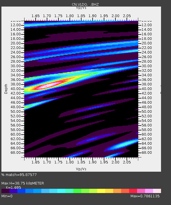
VLDQ VALDOR, QC - Earthquake Result Viewer

Earthquake location: Andreanof Islands, Aleutian Is.
Earthquake latitude/longitude: 51.5/-175.2
Earthquake time(UTC): 2013/08/30 (242) 16:25:02 GMT
Earthquake Depth: 29 km
Earthquake Magnitude: 7.0 MWW, 6.5 ML, 6.8 MI, 6.9 MWC, 6.9 MWB, 7.0 MWW, 7.0 MI, 7.0 MWC
Earthquake Catalog/Contributor: NEIC PDE/NEIC COMCAT
Network: CN Canadian National Seismograph Network
Station: VLDQ VALDOR, QC
Lat/Lon: 48.19 N/77.76 W
Elevation: 93 m
Distance: 58.3 deg
Az: 51.27 deg
Baz: 313.269 deg
Ray Param: 0.062911175
Estimated Moho Depth: 38.75 km
Estimated Crust Vp/Vs: 1.70
Assumed Crust Vp: 6.61 km/s
Estimated Crust Vs: 3.9 km/s
Estimated Crust Poisson's Ratio: 0.23
Radial Match: 95.87577 %
Radial Bump: 386
Transverse Match: 74.882454 %
Transverse Bump: 400
SOD ConfigId: 626651
Insert Time: 2014-04-18 04:57:19.172 +0000
GWidth: 2.5
Max Bumps: 400
Tol: 0.001

Signal To Noise

ChannelStoNSTALTA
CN:VLDQ: :BHZ:20130830T16:34:23.300Z7.99520871.6687001E-62.087125E-7
CN:VLDQ: :BHN:20130830T16:34:23.300Z2.31390026.291023E-72.7187963E-7
CN:VLDQ: :BHE:20130830T16:34:23.300Z3.48835235.762271E-71.6518602E-7
Arrivals
Ps4.3 SECOND
PpPs15 SECOND
PsPs/PpSs19 SECOND