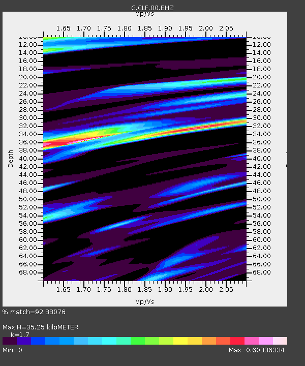
CLF Chambon la Foret observatory, France - Earthquake Result Viewer
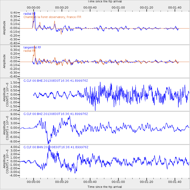
Earthquake location: Andreanof Islands, Aleutian Is.
Earthquake latitude/longitude: 51.5/-175.2
Earthquake time(UTC): 2013/08/30 (242) 16:25:02 GMT
Earthquake Depth: 29 km
Earthquake Magnitude: 7.0 MWW, 6.5 ML, 6.8 MI, 6.9 MWC, 6.9 MWB, 7.0 MWW, 7.0 MI, 7.0 MWC
Earthquake Catalog/Contributor: NEIC PDE/NEIC COMCAT
Network: G GEOSCOPE
Station: CLF Chambon la Foret observatory, France
Lat/Lon: 48.03 N/2.26 E
Elevation: 145 m
Distance: 80.8 deg
Az: 1.707 deg
Baz: 358.412 deg
Ray Param: 0.048000127
Estimated Moho Depth: 35.25 km
Estimated Crust Vp/Vs: 1.70
Assumed Crust Vp: 6.12 km/s
Estimated Crust Vs: 3.6 km/s
Estimated Crust Poisson's Ratio: 0.24
Radial Match: 92.88076 %
Radial Bump: 400
Transverse Match: 83.472885 %
Transverse Bump: 400
SOD ConfigId: 626651
Insert Time: 2014-04-18 04:58:48.644 +0000
GWidth: 2.5
Max Bumps: 400
Tol: 0.001

Signal To Noise

ChannelStoNSTALTA
G:CLF:00:BHZ:20130830T16:36:41.899976Z9.9638422.1693775E-62.1772499E-7
G:CLF:00:BHN:20130830T16:36:41.899976Z2.80381568.0766296E-72.880585E-7
G:CLF:00:BHE:20130830T16:36:41.899976Z0.997663262.2352457E-72.2404812E-7
Arrivals
Ps4.1 SECOND
PpPs15 SECOND
PsPs/PpSs19 SECOND