FDF Fort de France, Martinique France - Earthquake Result Viewer
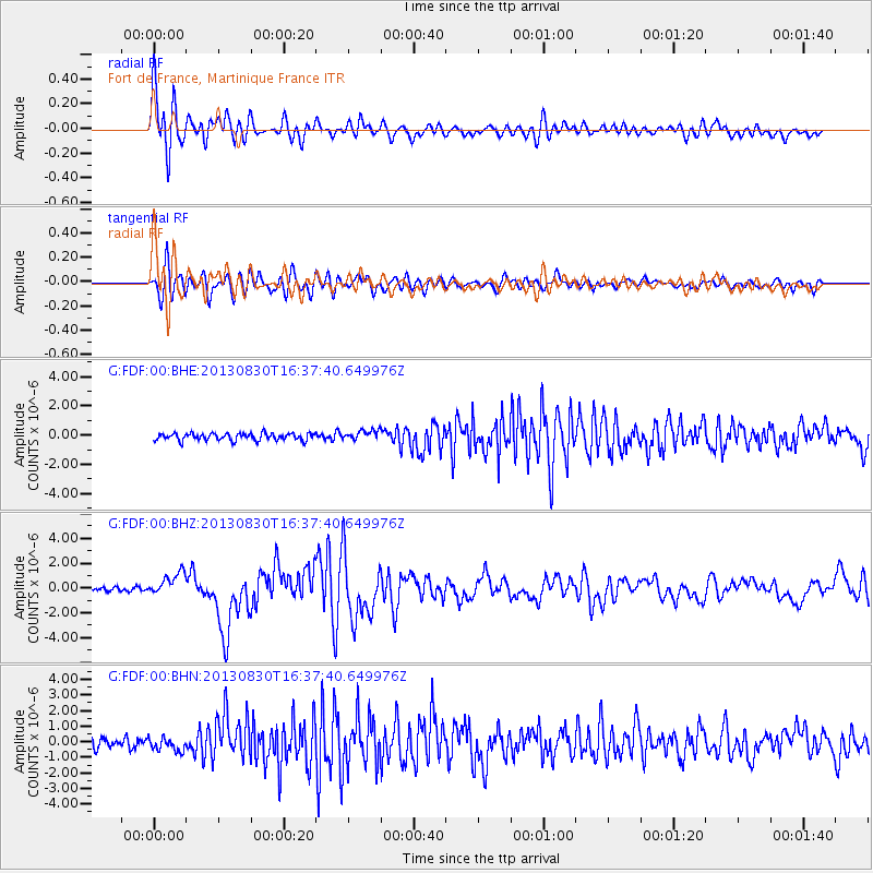
Earthquake location: Andreanof Islands, Aleutian Is.
Earthquake latitude/longitude: 51.5/-175.2
Earthquake time(UTC): 2013/08/30 (242) 16:25:02 GMT
Earthquake Depth: 29 km
Earthquake Magnitude: 7.0 MWW, 6.5 ML, 6.8 MI, 6.9 MWC, 6.9 MWB, 7.0 MWW, 7.0 MI, 7.0 MWC
Earthquake Catalog/Contributor: NEIC PDE/NEIC COMCAT
Network: G GEOSCOPE
Station: FDF Fort de France, Martinique France
Lat/Lon: 14.73 N/61.14 W
Elevation: 467 m
Distance: 92.8 deg
Az: 62.173 deg
Baz: 325.188 deg
Ray Param: 0.041373678
Estimated Moho Depth: 19.0 km
Estimated Crust Vp/Vs: 1.95
Assumed Crust Vp: 5.88 km/s
Estimated Crust Vs: 3.023 km/s
Estimated Crust Poisson's Ratio: 0.32
Radial Match: 87.89093 %
Radial Bump: 400
Transverse Match: 83.54362 %
Transverse Bump: 400
SOD ConfigId: 626651
Insert Time: 2014-04-18 04:58:54.057 +0000
GWidth: 2.5
Max Bumps: 400
Tol: 0.001

Signal To Noise

ChannelStoNSTALTA
G:FDF:00:BHZ:20130830T16:37:40.649976Z4.38830049.3330397E-72.1268005E-7
G:FDF:00:BHN:20130830T16:37:40.649976Z1.31104354.3810607E-73.3416592E-7
G:FDF:00:BHE:20130830T16:37:40.649976Z1.36179463.3540758E-72.462982E-7
Arrivals
Ps3.1 SECOND
PpPs9.4 SECOND
PsPs/PpSs12 SECOND