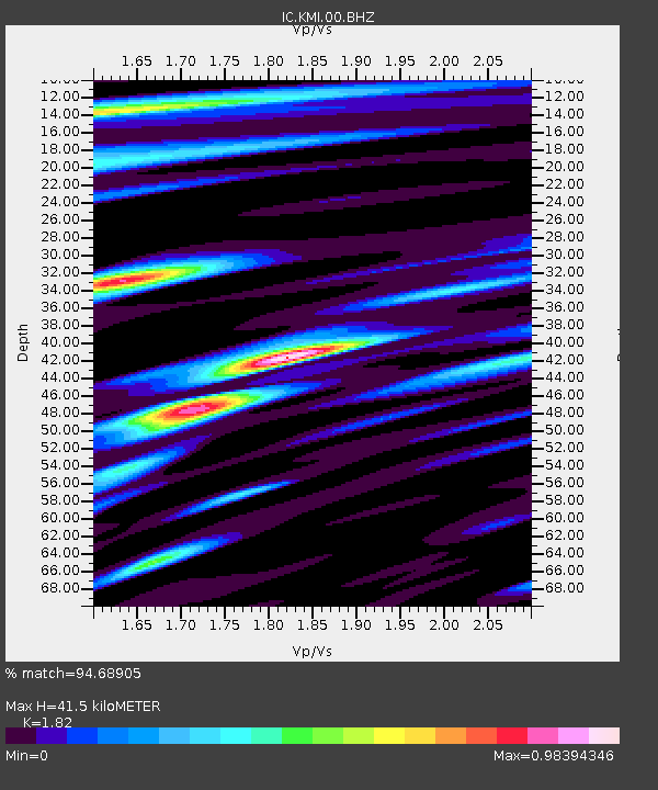
KMI Kunming, Yunnan Province, China - Earthquake Result Viewer

Earthquake location: Andreanof Islands, Aleutian Is.
Earthquake latitude/longitude: 51.5/-175.2
Earthquake time(UTC): 2013/08/30 (242) 16:25:02 GMT
Earthquake Depth: 29 km
Earthquake Magnitude: 7.0 MWW, 6.5 ML, 6.8 MI, 6.9 MWC, 6.9 MWB, 7.0 MWW, 7.0 MI, 7.0 MWC
Earthquake Catalog/Contributor: NEIC PDE/NEIC COMCAT
Network: IC New China Digital Seismograph Network
Station: KMI Kunming, Yunnan Province, China
Lat/Lon: 25.12 N/102.74 E
Elevation: 1975 m
Distance: 65.9 deg
Az: 280.449 deg
Baz: 42.654 deg
Ray Param: 0.05792224
Estimated Moho Depth: 41.5 km
Estimated Crust Vp/Vs: 1.82
Assumed Crust Vp: 6.247 km/s
Estimated Crust Vs: 3.432 km/s
Estimated Crust Poisson's Ratio: 0.28
Radial Match: 94.68905 %
Radial Bump: 400
Transverse Match: 87.13622 %
Transverse Bump: 400
SOD ConfigId: 626651
Insert Time: 2014-04-18 05:02:17.986 +0000
GWidth: 2.5
Max Bumps: 400
Tol: 0.001

Signal To Noise

ChannelStoNSTALTA
IC:KMI:00:BHZ:20130830T16:35:14.469006Z24.728712.9074718E-61.1757475E-7
IC:KMI:00:BH1:20130830T16:35:14.469006Z6.5306099.702329E-71.48567E-7
IC:KMI:00:BH2:20130830T16:35:14.469006Z6.45641857.2774105E-71.127159E-7
Arrivals
Ps5.7 SECOND
PpPs18 SECOND
PsPs/PpSs24 SECOND