You are here: Home > Network List > PS - Pacific21 Stations List
> Station PSI Parapat, Indonesia > Earthquake Result Viewer
PSI Parapat, Indonesia - Earthquake Result Viewer

| Earthquake location: |
Fiji Islands Region |
| Earthquake latitude/longitude: |
-15.2/173.1 |
| Earthquake time(UTC): |
2014/11/13 (317) 10:24:18 GMT |
| Earthquake Depth: |
10 km |
| Earthquake Magnitude: |
5.7 MB |
| Earthquake Catalog/Contributor: |
NEIC PDE/NEIC COMCAT |
|
| Network: |
PS Pacific21 |
| Station: |
PSI Parapat, Indonesia |
| Lat/Lon: |
2.69 N/98.92 E |
| Elevation: |
987 m |
|
| Distance: |
75.4 deg |
| Az: |
276.89 deg |
| Baz: |
106.326 deg |
| Ray Param: |
0.051678218 |
| Estimated Moho Depth: |
59.25 km |
| Estimated Crust Vp/Vs: |
1.66 |
| Assumed Crust Vp: |
6.468 km/s |
| Estimated Crust Vs: |
3.89 km/s |
| Estimated Crust Poisson's Ratio: |
0.22 |
|
| Radial Match: |
93.41465 % |
| Radial Bump: |
400 |
| Transverse Match: |
82.166466 % |
| Transverse Bump: |
400 |
| SOD ConfigId: |
3390531 |
| Insert Time: |
2019-04-14 23:25:30.928 +0000 |
| GWidth: |
2.5 |
| Max Bumps: |
400 |
| Tol: |
0.001 |
|
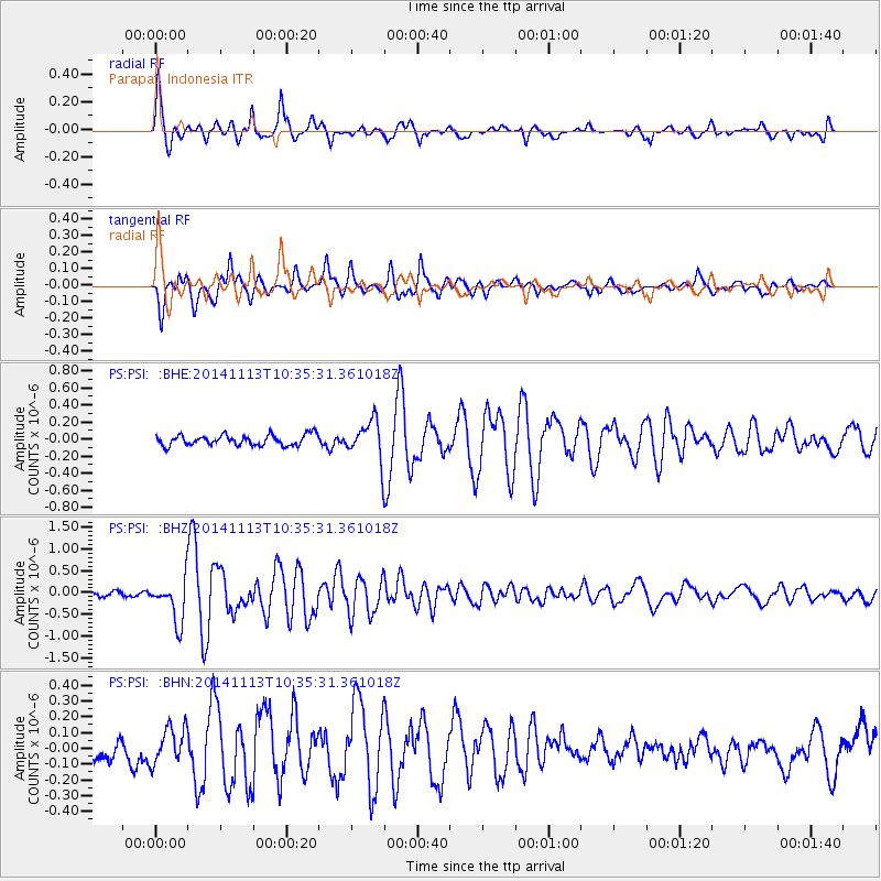
Signal To Noise
| Channel | StoN | STA | LTA |
| PS:PSI: :BHZ:20141113T10:35:31.361018Z | 6.868321 | 4.9230584E-7 | 7.167776E-8 |
| PS:PSI: :BHN:20141113T10:35:31.361018Z | 1.415722 | 1.098085E-7 | 7.7563605E-8 |
| PS:PSI: :BHE:20141113T10:35:31.361018Z | 2.7792594 | 1.7198509E-7 | 6.188162E-8 |
| Arrivals |
| Ps | 6.3 SECOND |
| PpPs | 24 SECOND |
| PsPs/PpSs | 30 SECOND |


