WMQ Urumqi, Xinjiang Province, China - Earthquake Result Viewer
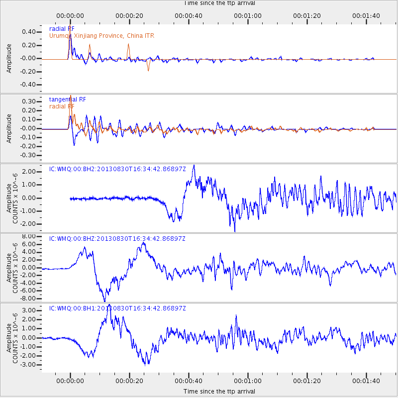
Earthquake location: Andreanof Islands, Aleutian Is.
Earthquake latitude/longitude: 51.5/-175.2
Earthquake time(UTC): 2013/08/30 (242) 16:25:02 GMT
Earthquake Depth: 29 km
Earthquake Magnitude: 7.0 MWW, 6.5 ML, 6.8 MI, 6.9 MWC, 6.9 MWB, 7.0 MWW, 7.0 MI, 7.0 MWC
Earthquake Catalog/Contributor: NEIC PDE/NEIC COMCAT
Network: IC New China Digital Seismograph Network
Station: WMQ Urumqi, Xinjiang Province, China
Lat/Lon: 43.81 N/87.70 E
Elevation: 850 m
Distance: 61.1 deg
Az: 304.86 deg
Baz: 45.068 deg
Ray Param: 0.061043963
Estimated Moho Depth: 10.0 km
Estimated Crust Vp/Vs: 1.78
Assumed Crust Vp: 6.242 km/s
Estimated Crust Vs: 3.507 km/s
Estimated Crust Poisson's Ratio: 0.27
Radial Match: 97.10698 %
Radial Bump: 370
Transverse Match: 83.185265 %
Transverse Bump: 400
SOD ConfigId: 626651
Insert Time: 2014-04-18 05:02:29.987 +0000
GWidth: 2.5
Max Bumps: 400
Tol: 0.001

Signal To Noise

ChannelStoNSTALTA
IC:WMQ:00:BHZ:20130830T16:34:42.86897Z32.476092.7959852E-68.609366E-8
IC:WMQ:00:BH1:20130830T16:34:42.86897Z10.9298948.0718553E-77.3851176E-8
IC:WMQ:00:BH2:20130830T16:34:42.86897Z16.0715038.7071186E-75.4177377E-8
Arrivals
Ps1.3 SECOND
PpPs4.3 SECOND
PsPs/PpSs5.6 SECOND