ABKT Alibek, Turkmenistan - Earthquake Result Viewer
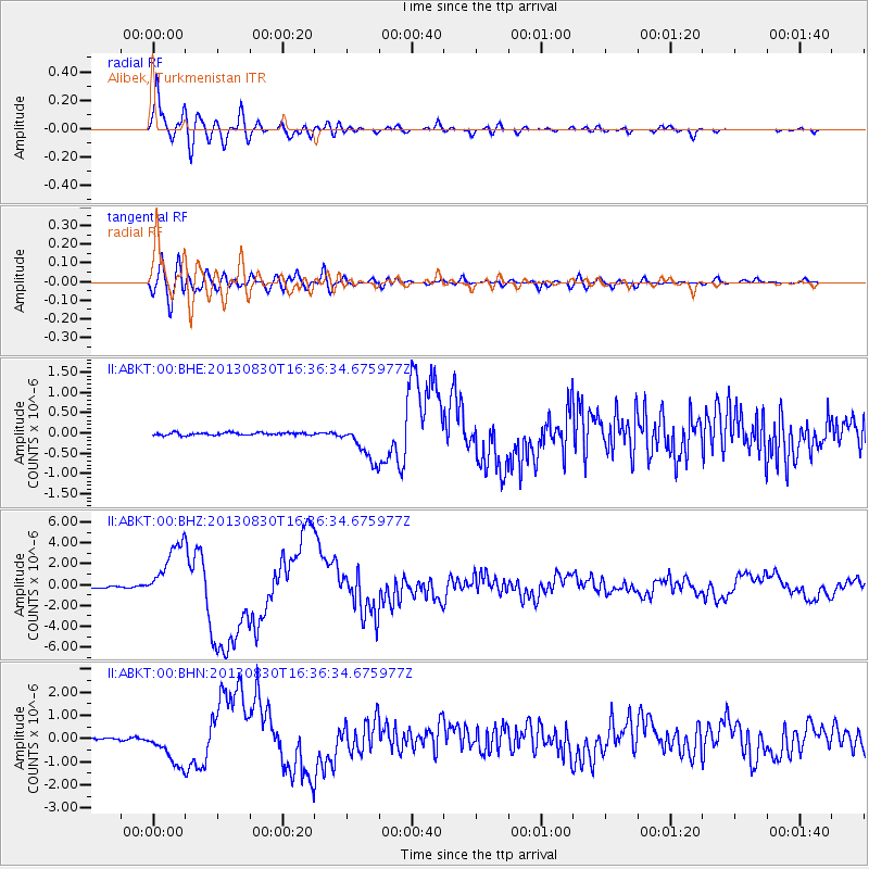
Earthquake location: Andreanof Islands, Aleutian Is.
Earthquake latitude/longitude: 51.5/-175.2
Earthquake time(UTC): 2013/08/30 (242) 16:25:02 GMT
Earthquake Depth: 29 km
Earthquake Magnitude: 7.0 MWW, 6.5 ML, 6.8 MI, 6.9 MWC, 6.9 MWB, 7.0 MWW, 7.0 MI, 7.0 MWC
Earthquake Catalog/Contributor: NEIC PDE/NEIC COMCAT
Network: II Global Seismograph Network (GSN - IRIS/IDA)
Station: ABKT Alibek, Turkmenistan
Lat/Lon: 37.93 N/58.12 E
Elevation: 678 m
Distance: 79.4 deg
Az: 319.809 deg
Baz: 30.645 deg
Ray Param: 0.04892129
Estimated Moho Depth: 12.5 km
Estimated Crust Vp/Vs: 1.61
Assumed Crust Vp: 6.53 km/s
Estimated Crust Vs: 4.05 km/s
Estimated Crust Poisson's Ratio: 0.19
Radial Match: 95.961174 %
Radial Bump: 400
Transverse Match: 82.41348 %
Transverse Bump: 400
SOD ConfigId: 626651
Insert Time: 2014-04-18 05:02:37.314 +0000
GWidth: 2.5
Max Bumps: 400
Tol: 0.001

Signal To Noise

ChannelStoNSTALTA
II:ABKT:00:BHZ:20130830T16:36:34.675977Z45.212422.8318316E-66.263393E-8
II:ABKT:00:BHN:20130830T16:36:34.675977Z21.1545988.067872E-73.8137678E-8
II:ABKT:00:BHE:20130830T16:36:34.675977Z14.5214674.585289E-73.1575933E-8
Arrivals
Ps1.2 SECOND
PpPs4.8 SECOND
PsPs/PpSs6.1 SECOND