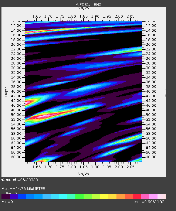
PD31 PDAR Array, Pinedale, WY, USA - Earthquake Result Viewer

Earthquake location: Andreanof Islands, Aleutian Is.
Earthquake latitude/longitude: 51.5/-175.2
Earthquake time(UTC): 2013/08/30 (242) 16:25:02 GMT
Earthquake Depth: 29 km
Earthquake Magnitude: 7.0 MWW, 6.5 ML, 6.8 MI, 6.9 MWC, 6.9 MWB, 7.0 MWW, 7.0 MI, 7.0 MWC
Earthquake Catalog/Contributor: NEIC PDE/NEIC COMCAT
Network: IM International Miscellaneous Stations
Station: PD31 PDAR Array, Pinedale, WY, USA
Lat/Lon: 42.77 N/109.56 W
Elevation: 2219 m
Distance: 44.1 deg
Az: 74.535 deg
Baz: 305.17 deg
Ray Param: 0.072058156
Estimated Moho Depth: 44.75 km
Estimated Crust Vp/Vs: 1.60
Assumed Crust Vp: 6.161 km/s
Estimated Crust Vs: 3.851 km/s
Estimated Crust Poisson's Ratio: 0.18
Radial Match: 95.38333 %
Radial Bump: 400
Transverse Match: 92.437485 %
Transverse Bump: 400
SOD ConfigId: 626651
Insert Time: 2014-04-18 05:03:16.634 +0000
GWidth: 2.5
Max Bumps: 400
Tol: 0.001

Signal To Noise

ChannelStoNSTALTA
IM:PD31: :BHZ:20130830T16:32:37.423993Z33.885049.675878E-82.8555014E-9
IM:PD31: :BHN:20130830T16:32:37.423993Z11.539312.9331966E-82.5419167E-9
IM:PD31: :BHE:20130830T16:32:37.423993Z8.0667482.0121757E-82.4944073E-9
Arrivals
Ps4.7 SECOND
PpPs18 SECOND
PsPs/PpSs22 SECOND