KBL Kabul, Afghanistan - Earthquake Result Viewer
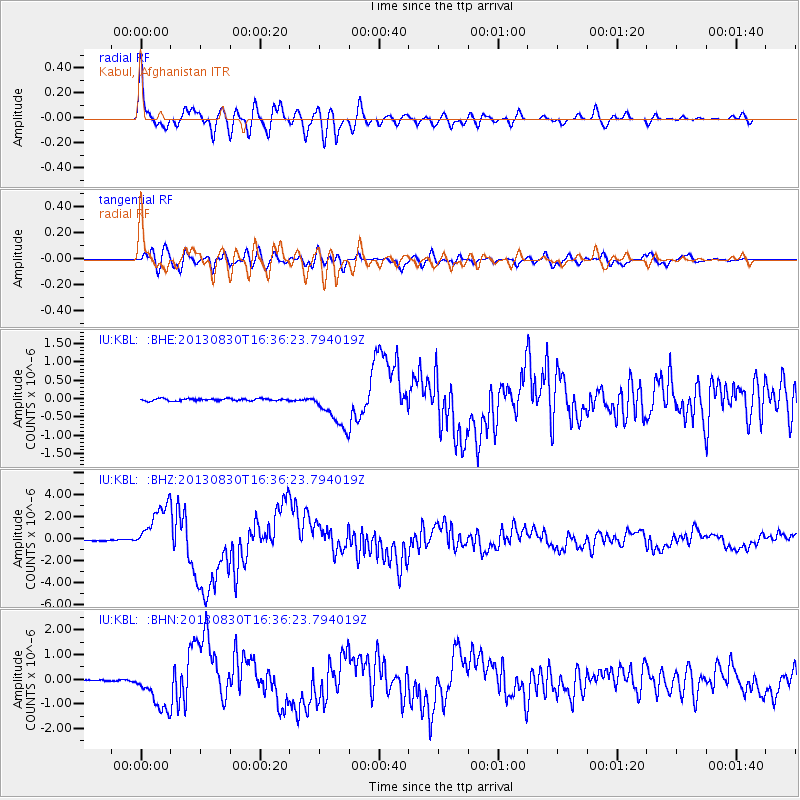
Earthquake location: Andreanof Islands, Aleutian Is.
Earthquake latitude/longitude: 51.5/-175.2
Earthquake time(UTC): 2013/08/30 (242) 16:25:02 GMT
Earthquake Depth: 29 km
Earthquake Magnitude: 7.0 MWW, 6.5 ML, 6.8 MI, 6.9 MWC, 6.9 MWB, 7.0 MWW, 7.0 MI, 7.0 MWC
Earthquake Catalog/Contributor: NEIC PDE/NEIC COMCAT
Network: IU Global Seismograph Network (GSN - IRIS/USGS)
Station: KBL Kabul, Afghanistan
Lat/Lon: 34.54 N/69.04 E
Elevation: 1920 m
Distance: 77.5 deg
Az: 310.376 deg
Baz: 35.197 deg
Ray Param: 0.050264113
Estimated Moho Depth: 56.0 km
Estimated Crust Vp/Vs: 1.86
Assumed Crust Vp: 6.641 km/s
Estimated Crust Vs: 3.566 km/s
Estimated Crust Poisson's Ratio: 0.30
Radial Match: 93.327446 %
Radial Bump: 400
Transverse Match: 82.987144 %
Transverse Bump: 400
SOD ConfigId: 626651
Insert Time: 2014-04-18 05:03:49.372 +0000
GWidth: 2.5
Max Bumps: 400
Tol: 0.001

Signal To Noise

ChannelStoNSTALTA
IU:KBL: :BHZ:20130830T16:36:23.794019Z52.8873252.2190623E-64.1958298E-8
IU:KBL: :BHN:20130830T16:36:23.794019Z24.3333348.498282E-73.4924447E-8
IU:KBL: :BHE:20130830T16:36:23.794019Z18.2586025.3114627E-72.9090193E-8
Arrivals
Ps7.5 SECOND
PpPs23 SECOND
PsPs/PpSs31 SECOND