MAKZ Makanchi, Kazakhstan - Earthquake Result Viewer
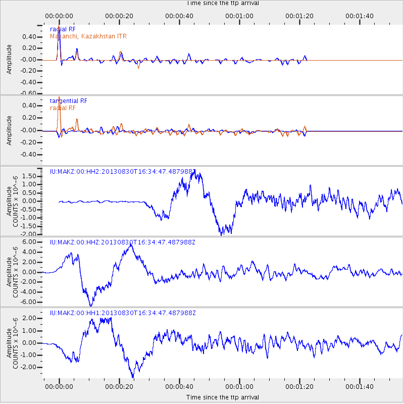
Earthquake location: Andreanof Islands, Aleutian Is.
Earthquake latitude/longitude: 51.5/-175.2
Earthquake time(UTC): 2013/08/30 (242) 16:25:02 GMT
Earthquake Depth: 29 km
Earthquake Magnitude: 7.0 MWW, 6.5 ML, 6.8 MI, 6.9 MWC, 6.9 MWB, 7.0 MWW, 7.0 MI, 7.0 MWC
Earthquake Catalog/Contributor: NEIC PDE/NEIC COMCAT
Network: IU Global Seismograph Network (GSN - IRIS/USGS)
Station: MAKZ Makanchi, Kazakhstan
Lat/Lon: 46.81 N/81.98 E
Elevation: 600 m
Distance: 61.8 deg
Az: 310.53 deg
Baz: 43.718 deg
Ray Param: 0.060601484
Estimated Moho Depth: 52.75 km
Estimated Crust Vp/Vs: 1.71
Assumed Crust Vp: 6.571 km/s
Estimated Crust Vs: 3.854 km/s
Estimated Crust Poisson's Ratio: 0.24
Radial Match: 97.01588 %
Radial Bump: 400
Transverse Match: 89.78496 %
Transverse Bump: 400
SOD ConfigId: 626651
Insert Time: 2014-04-18 05:04:01.090 +0000
GWidth: 2.5
Max Bumps: 400
Tol: 0.001

Signal To Noise

ChannelStoNSTALTA
IU:MAKZ:00:HHZ:20130830T16:34:47.487988Z35.1173822.4768447E-67.053045E-8
IU:MAKZ:00:HH1:20130830T16:34:47.487988Z28.270689.1478773E-73.235818E-8
IU:MAKZ:00:HH2:20130830T16:34:47.487988Z20.0490846.4731574E-73.228655E-8
Arrivals
Ps5.9 SECOND
PpPs21 SECOND
PsPs/PpSs27 SECOND