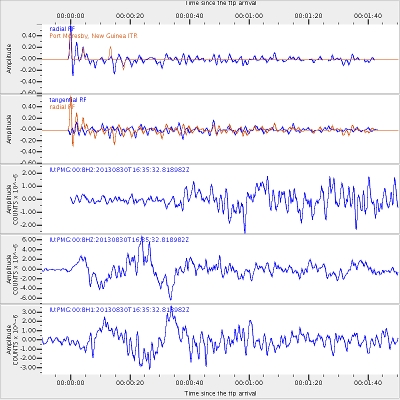
PMG Port Moresby, New Guinea - Earthquake Result Viewer
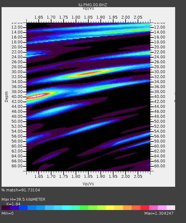
Earthquake location: Andreanof Islands, Aleutian Is.
Earthquake latitude/longitude: 51.5/-175.2
Earthquake time(UTC): 2013/08/30 (242) 16:25:02 GMT
Earthquake Depth: 29 km
Earthquake Magnitude: 7.0 MWW, 6.5 ML, 6.8 MI, 6.9 MWC, 6.9 MWB, 7.0 MWW, 7.0 MI, 7.0 MWC
Earthquake Catalog/Contributor: NEIC PDE/NEIC COMCAT
Network: IU Global Seismograph Network (GSN - IRIS/USGS)
Station: PMG Port Moresby, New Guinea
Lat/Lon: 9.40 S/147.16 E
Elevation: 90 m
Distance: 68.8 deg
Az: 220.23 deg
Baz: 24.13 deg
Ray Param: 0.05601766
Estimated Moho Depth: 39.5 km
Estimated Crust Vp/Vs: 1.64
Assumed Crust Vp: 6.122 km/s
Estimated Crust Vs: 3.733 km/s
Estimated Crust Poisson's Ratio: 0.20
Radial Match: 91.73104 %
Radial Bump: 400
Transverse Match: 76.954384 %
Transverse Bump: 400
SOD ConfigId: 626651
Insert Time: 2014-04-18 05:04:07.695 +0000
GWidth: 2.5
Max Bumps: 400
Tol: 0.001

Signal To Noise

ChannelStoNSTALTA
IU:PMG:00:BHZ:20130830T16:35:32.818982Z8.8615851.5724535E-61.7744607E-7
IU:PMG:00:BH1:20130830T16:35:32.818982Z1.97202685.125467E-72.599086E-7
IU:PMG:00:BH2:20130830T16:35:32.818982Z1.44397472.7015005E-71.870878E-7
Arrivals
Ps4.3 SECOND
PpPs16 SECOND
PsPs/PpSs21 SECOND