TEIG Tepich, Yucatan, Mexico - Earthquake Result Viewer
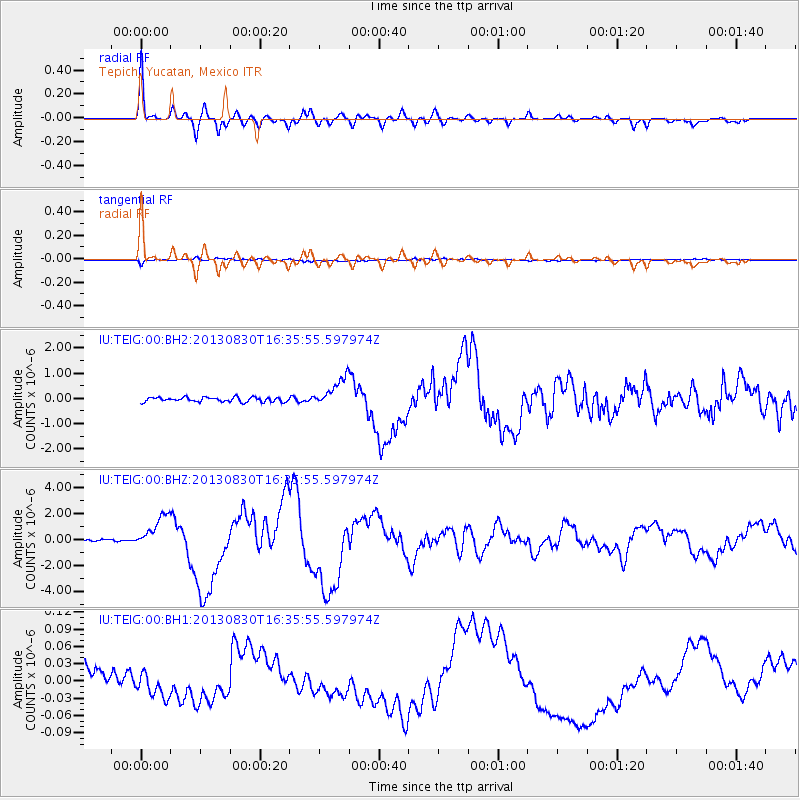
Earthquake location: Andreanof Islands, Aleutian Is.
Earthquake latitude/longitude: 51.5/-175.2
Earthquake time(UTC): 2013/08/30 (242) 16:25:02 GMT
Earthquake Depth: 29 km
Earthquake Magnitude: 7.0 MWW, 6.5 ML, 6.8 MI, 6.9 MWC, 6.9 MWB, 7.0 MWW, 7.0 MI, 7.0 MWC
Earthquake Catalog/Contributor: NEIC PDE/NEIC COMCAT
Network: IU Global Seismograph Network (GSN - IRIS/USGS)
Station: TEIG Tepich, Yucatan, Mexico
Lat/Lon: 20.23 N/88.28 W
Elevation: 40 m
Distance: 72.6 deg
Az: 79.389 deg
Baz: 319.178 deg
Ray Param: 0.053535964
Estimated Moho Depth: 16.25 km
Estimated Crust Vp/Vs: 1.72
Assumed Crust Vp: 5.817 km/s
Estimated Crust Vs: 3.382 km/s
Estimated Crust Poisson's Ratio: 0.24
Radial Match: 95.91483 %
Radial Bump: 400
Transverse Match: 93.48954 %
Transverse Bump: 400
SOD ConfigId: 626651
Insert Time: 2014-04-18 05:04:26.947 +0000
GWidth: 2.5
Max Bumps: 400
Tol: 0.001

Signal To Noise

ChannelStoNSTALTA
IU:TEIG:00:BHZ:20130830T16:35:55.597974Z14.1973541.2810227E-69.0229676E-8
IU:TEIG:00:BH1:20130830T16:35:55.597974Z0.84956972.1767105E-82.562133E-8
IU:TEIG:00:BH2:20130830T16:35:55.597974Z6.31970265.634711E-78.916101E-8
Arrivals
Ps2.1 SECOND
PpPs7.4 SECOND
PsPs/PpSs9.5 SECOND