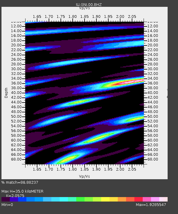
GNI Garni, Armenia - Earthquake Result Viewer
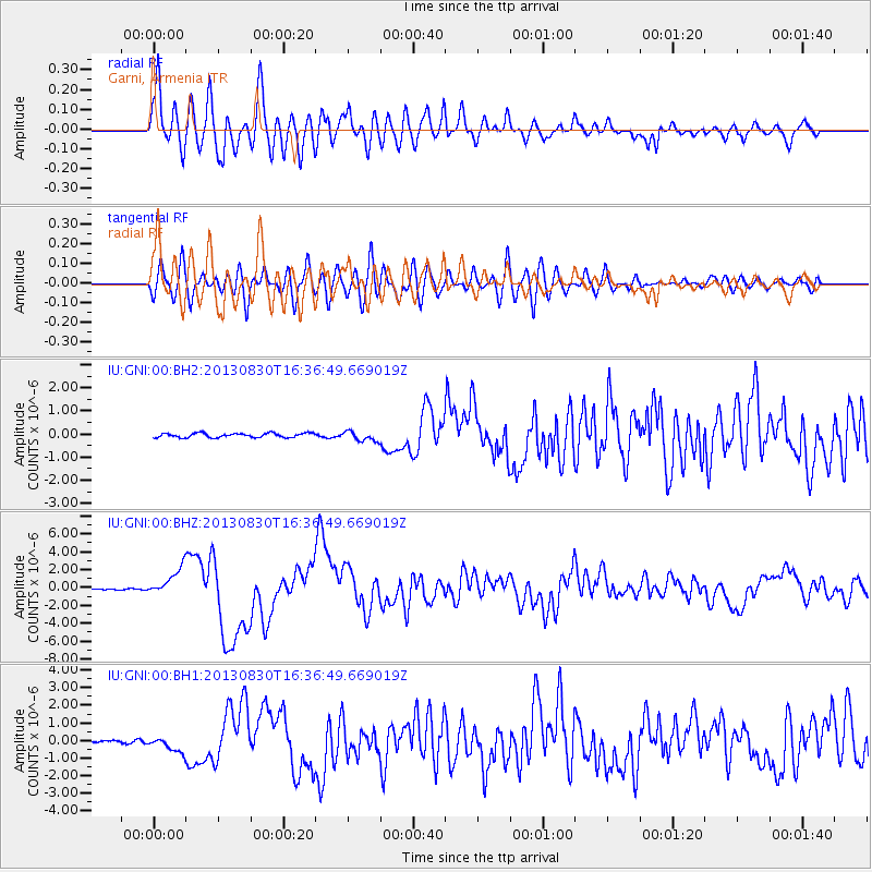
Earthquake location: Andreanof Islands, Aleutian Is.
Earthquake latitude/longitude: 51.5/-175.2
Earthquake time(UTC): 2013/08/30 (242) 16:25:02 GMT
Earthquake Depth: 29 km
Earthquake Magnitude: 7.0 MWW, 6.5 ML, 6.8 MI, 6.9 MWC, 6.9 MWB, 7.0 MWW, 7.0 MI, 7.0 MWC
Earthquake Catalog/Contributor: NEIC PDE/NEIC COMCAT
Network: IU Global Seismograph Network (GSN - IRIS/USGS)
Station: GNI Garni, Armenia
Lat/Lon: 40.15 N/44.74 E
Elevation: 1609 m
Distance: 82.3 deg
Az: 330.203 deg
Baz: 23.885 deg
Ray Param: 0.046974484
Estimated Moho Depth: 35.0 km
Estimated Crust Vp/Vs: 2.06
Assumed Crust Vp: 6.291 km/s
Estimated Crust Vs: 3.057 km/s
Estimated Crust Poisson's Ratio: 0.35
Radial Match: 86.88237 %
Radial Bump: 400
Transverse Match: 78.60273 %
Transverse Bump: 400
SOD ConfigId: 626651
Insert Time: 2014-04-18 05:04:40.523 +0000
GWidth: 2.5
Max Bumps: 400
Tol: 0.001

Signal To Noise

ChannelStoNSTALTA
IU:GNI:00:BHZ:20130830T16:36:49.669019Z17.3015941.5806116E-69.135641E-8
IU:GNI:00:BH1:20130830T16:36:49.669019Z5.98310234.194825E-77.0111206E-8
IU:GNI:00:BH2:20130830T16:36:49.669019Z2.30948692.1403778E-79.267764E-8
Arrivals
Ps6.0 SECOND
PpPs17 SECOND
PsPs/PpSs23 SECOND