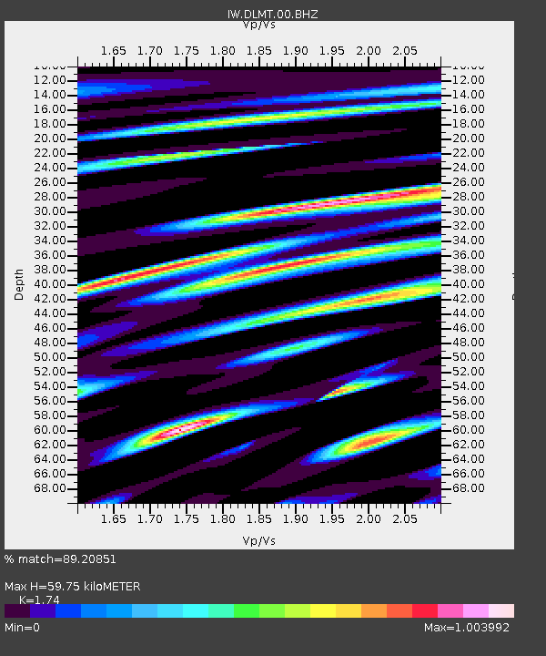
DLMT Dillon, Montana, USA - Earthquake Result Viewer
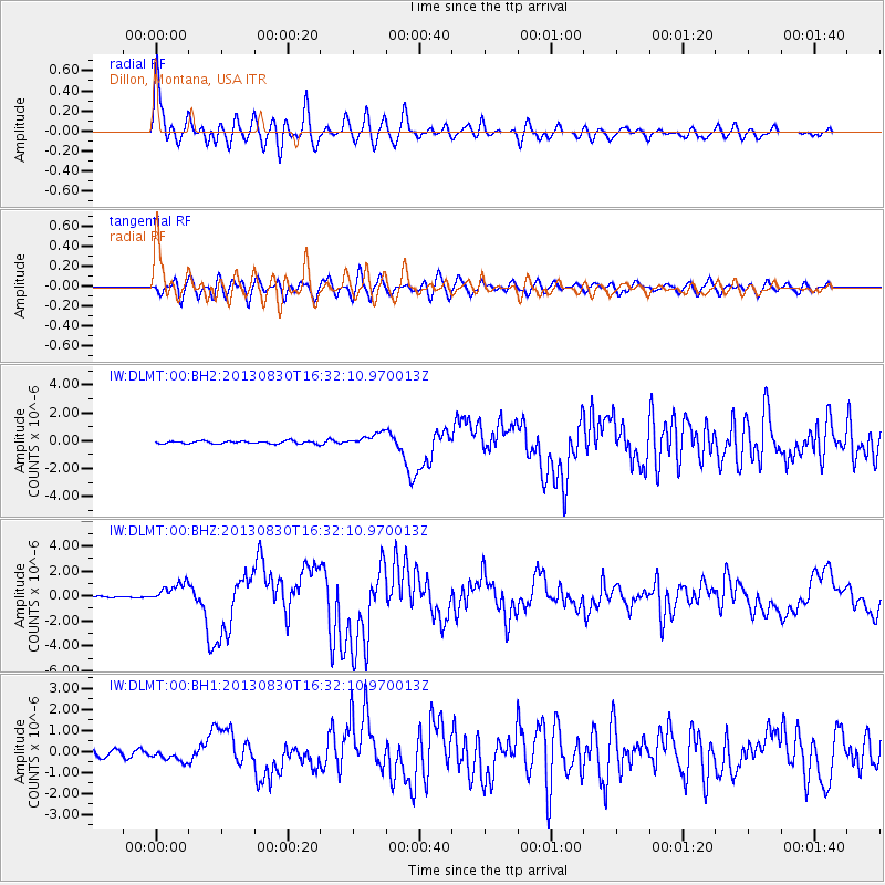
Earthquake location: Andreanof Islands, Aleutian Is.
Earthquake latitude/longitude: 51.5/-175.2
Earthquake time(UTC): 2013/08/30 (242) 16:25:02 GMT
Earthquake Depth: 29 km
Earthquake Magnitude: 7.0 MWW, 6.5 ML, 6.8 MI, 6.9 MWC, 6.9 MWB, 7.0 MWW, 7.0 MI, 7.0 MWC
Earthquake Catalog/Contributor: NEIC PDE/NEIC COMCAT
Network: IW Intermountain West
Station: DLMT Dillon, Montana, USA
Lat/Lon: 45.36 N/112.60 W
Elevation: 1569 m
Distance: 40.9 deg
Az: 73.131 deg
Baz: 302.028 deg
Ray Param: 0.074095435
Estimated Moho Depth: 59.75 km
Estimated Crust Vp/Vs: 1.74
Assumed Crust Vp: 6.577 km/s
Estimated Crust Vs: 3.78 km/s
Estimated Crust Poisson's Ratio: 0.25
Radial Match: 89.20851 %
Radial Bump: 400
Transverse Match: 74.34027 %
Transverse Bump: 400
SOD ConfigId: 626651
Insert Time: 2014-04-18 05:04:49.662 +0000
GWidth: 2.5
Max Bumps: 400
Tol: 0.001

Signal To Noise

ChannelStoNSTALTA
IW:DLMT:00:BHZ:20130830T16:32:10.970013Z11.9896667.9322604E-76.615914E-8
IW:DLMT:00:BH1:20130830T16:32:10.970013Z1.71970212.9483726E-71.714467E-7
IW:DLMT:00:BH2:20130830T16:32:10.970013Z4.73374134.6445408E-79.811564E-8
Arrivals
Ps7.2 SECOND
PpPs23 SECOND
PsPs/PpSs30 SECOND