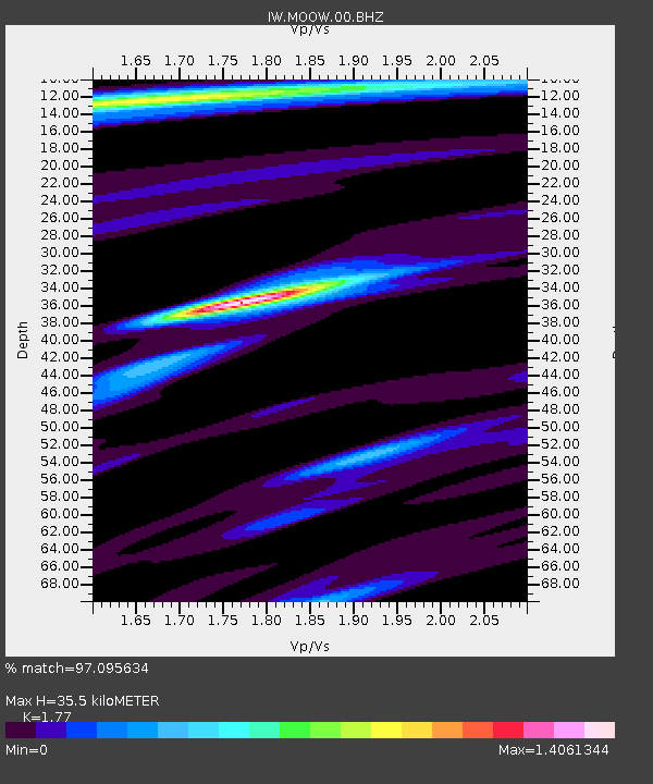
MOOW Moose Ponds, Wyoming, USA - Earthquake Result Viewer
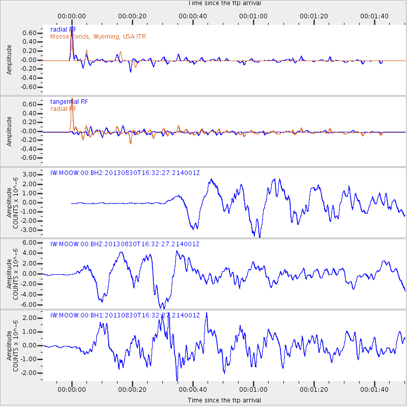
Earthquake location: Andreanof Islands, Aleutian Is.
Earthquake latitude/longitude: 51.5/-175.2
Earthquake time(UTC): 2013/08/30 (242) 16:25:02 GMT
Earthquake Depth: 29 km
Earthquake Magnitude: 7.0 MWW, 6.5 ML, 6.8 MI, 6.9 MWC, 6.9 MWB, 7.0 MWW, 7.0 MI, 7.0 MWC
Earthquake Catalog/Contributor: NEIC PDE/NEIC COMCAT
Network: IW Intermountain West
Station: MOOW Moose Ponds, Wyoming, USA
Lat/Lon: 43.75 N/110.74 W
Elevation: 2128 m
Distance: 42.9 deg
Az: 74.077 deg
Baz: 304.027 deg
Ray Param: 0.072870985
Estimated Moho Depth: 35.5 km
Estimated Crust Vp/Vs: 1.77
Assumed Crust Vp: 6.207 km/s
Estimated Crust Vs: 3.507 km/s
Estimated Crust Poisson's Ratio: 0.27
Radial Match: 97.095634 %
Radial Bump: 323
Transverse Match: 78.68181 %
Transverse Bump: 400
SOD ConfigId: 626651
Insert Time: 2014-04-18 05:05:04.107 +0000
GWidth: 2.5
Max Bumps: 400
Tol: 0.001

Signal To Noise

ChannelStoNSTALTA
IW:MOOW:00:BHZ:20130830T16:32:27.214001Z11.1844027.5317814E-76.734184E-8
IW:MOOW:00:BH1:20130830T16:32:27.214001Z5.0308812.6100656E-75.188089E-8
IW:MOOW:00:BH2:20130830T16:32:27.214001Z12.0484833.9091353E-73.244504E-8
Arrivals
Ps4.7 SECOND
PpPs15 SECOND
PsPs/PpSs20 SECOND