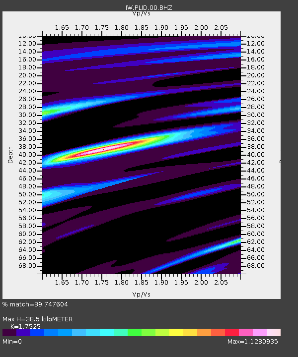
PLID Pearl Lake, Idaho, USA - Earthquake Result Viewer
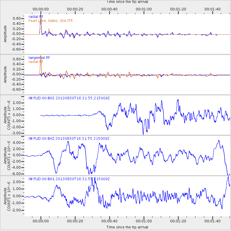
Earthquake location: Andreanof Islands, Aleutian Is.
Earthquake latitude/longitude: 51.5/-175.2
Earthquake time(UTC): 2013/08/30 (242) 16:25:02 GMT
Earthquake Depth: 29 km
Earthquake Magnitude: 7.0 MWW, 6.5 ML, 6.8 MI, 6.9 MWC, 6.9 MWB, 7.0 MWW, 7.0 MI, 7.0 MWC
Earthquake Catalog/Contributor: NEIC PDE/NEIC COMCAT
Network: IW Intermountain West
Station: PLID Pearl Lake, Idaho, USA
Lat/Lon: 45.09 N/116.00 W
Elevation: 2164 m
Distance: 39.0 deg
Az: 75.467 deg
Baz: 301.411 deg
Ray Param: 0.07520794
Estimated Moho Depth: 38.5 km
Estimated Crust Vp/Vs: 1.75
Assumed Crust Vp: 6.571 km/s
Estimated Crust Vs: 3.749 km/s
Estimated Crust Poisson's Ratio: 0.26
Radial Match: 89.747604 %
Radial Bump: 400
Transverse Match: 62.39099 %
Transverse Bump: 400
SOD ConfigId: 626651
Insert Time: 2014-04-18 05:05:08.881 +0000
GWidth: 2.5
Max Bumps: 400
Tol: 0.001

Signal To Noise

ChannelStoNSTALTA
IW:PLID:00:BHZ:20130830T16:31:55.215009Z9.9844899.2294715E-79.243809E-8
IW:PLID:00:BH1:20130830T16:31:55.215009Z5.33800843.0819066E-75.7735143E-8
IW:PLID:00:BH2:20130830T16:31:55.215009Z10.2902983.895584E-73.785686E-8
Arrivals
Ps4.8 SECOND
PpPs15 SECOND
PsPs/PpSs20 SECOND