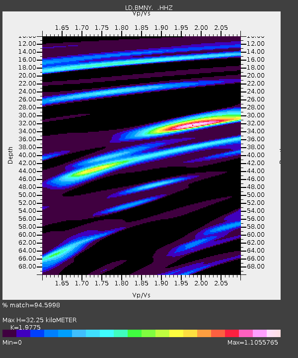
BMNY Brushton-Moira, New York - Earthquake Result Viewer

Earthquake location: Andreanof Islands, Aleutian Is.
Earthquake latitude/longitude: 51.5/-175.2
Earthquake time(UTC): 2013/08/30 (242) 16:25:02 GMT
Earthquake Depth: 29 km
Earthquake Magnitude: 7.0 MWW, 6.5 ML, 6.8 MI, 6.9 MWC, 6.9 MWB, 7.0 MWW, 7.0 MI, 7.0 MWC
Earthquake Catalog/Contributor: NEIC PDE/NEIC COMCAT
Network: LD Lamont-Doherty Cooperative Seismographic Network
Station: BMNY Brushton-Moira, New York
Lat/Lon: 44.84 N/74.51 W
Elevation: 115 m
Distance: 62.2 deg
Az: 52.196 deg
Baz: 316.082 deg
Ray Param: 0.060327977
Estimated Moho Depth: 32.25 km
Estimated Crust Vp/Vs: 1.98
Assumed Crust Vp: 6.419 km/s
Estimated Crust Vs: 3.246 km/s
Estimated Crust Poisson's Ratio: 0.33
Radial Match: 94.5998 %
Radial Bump: 379
Transverse Match: 63.483284 %
Transverse Bump: 400
SOD ConfigId: 626651
Insert Time: 2014-04-18 05:06:26.889 +0000
GWidth: 2.5
Max Bumps: 400
Tol: 0.001

Signal To Noise

ChannelStoNSTALTA
LD:BMNY: :HHZ:20130830T16:34:50.274976Z14.8819862.225851E-61.495668E-7
LD:BMNY: :HHN:20130830T16:34:50.274976Z4.15075067.0547605E-71.6996349E-7
LD:BMNY: :HHE:20130830T16:34:50.274976Z6.52934178.576117E-71.3134735E-7
Arrivals
Ps5.1 SECOND
PpPs14 SECOND
PsPs/PpSs19 SECOND