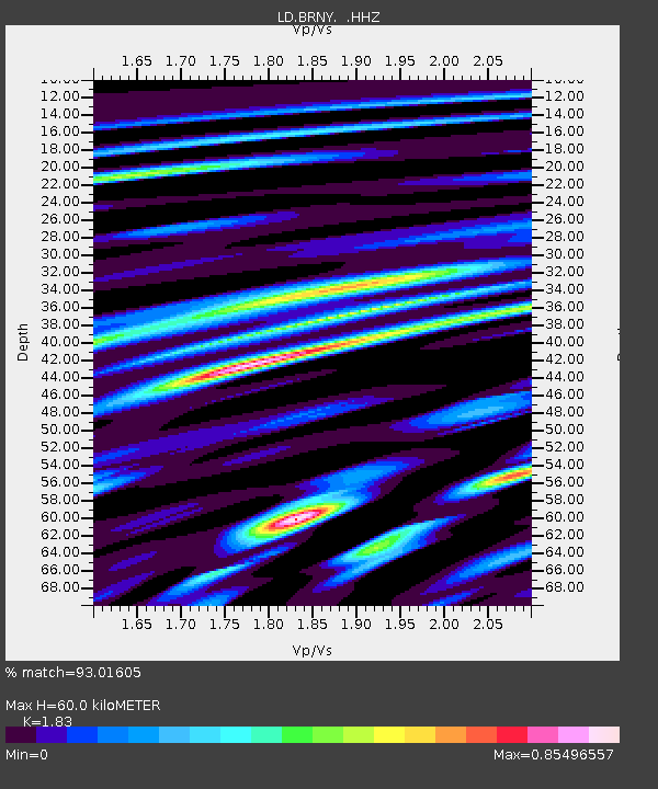
BRNY Black Rock Forest, Cornwall, NY - Earthquake Result Viewer

Earthquake location: Andreanof Islands, Aleutian Is.
Earthquake latitude/longitude: 51.5/-175.2
Earthquake time(UTC): 2013/08/30 (242) 16:25:02 GMT
Earthquake Depth: 29 km
Earthquake Magnitude: 7.0 MWW, 6.5 ML, 6.8 MI, 6.9 MWC, 6.9 MWB, 7.0 MWW, 7.0 MI, 7.0 MWC
Earthquake Catalog/Contributor: NEIC PDE/NEIC COMCAT
Network: LD Lamont-Doherty Cooperative Seismographic Network
Station: BRNY Black Rock Forest, Cornwall, NY
Lat/Lon: 41.41 N/74.01 W
Elevation: 248 m
Distance: 65.0 deg
Az: 54.52 deg
Baz: 317.453 deg
Ray Param: 0.05854297
Estimated Moho Depth: 60.0 km
Estimated Crust Vp/Vs: 1.83
Assumed Crust Vp: 6.283 km/s
Estimated Crust Vs: 3.434 km/s
Estimated Crust Poisson's Ratio: 0.29
Radial Match: 93.01605 %
Radial Bump: 400
Transverse Match: 77.304924 %
Transverse Bump: 400
SOD ConfigId: 626651
Insert Time: 2014-04-18 05:06:31.777 +0000
GWidth: 2.5
Max Bumps: 400
Tol: 0.001

Signal To Noise

ChannelStoNSTALTA
LD:BRNY: :HHZ:20130830T16:35:08.352002Z7.246232.1964843E-63.0312094E-7
LD:BRNY: :HHN:20130830T16:35:08.352002Z3.25010639.513482E-72.9271294E-7
LD:BRNY: :HHE:20130830T16:35:08.352002Z2.80726867.442934E-72.651308E-7
Arrivals
Ps8.2 SECOND
PpPs26 SECOND
PsPs/PpSs34 SECOND