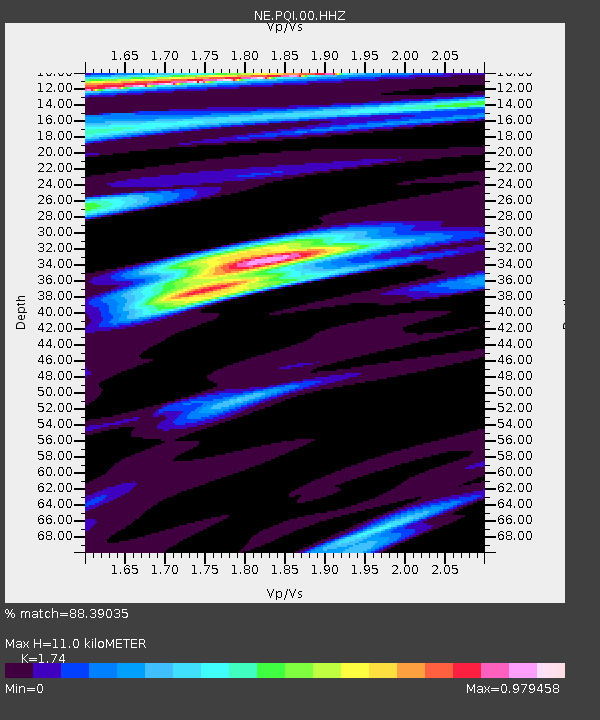
PQI Presque Isle, ME, USA - Earthquake Result Viewer
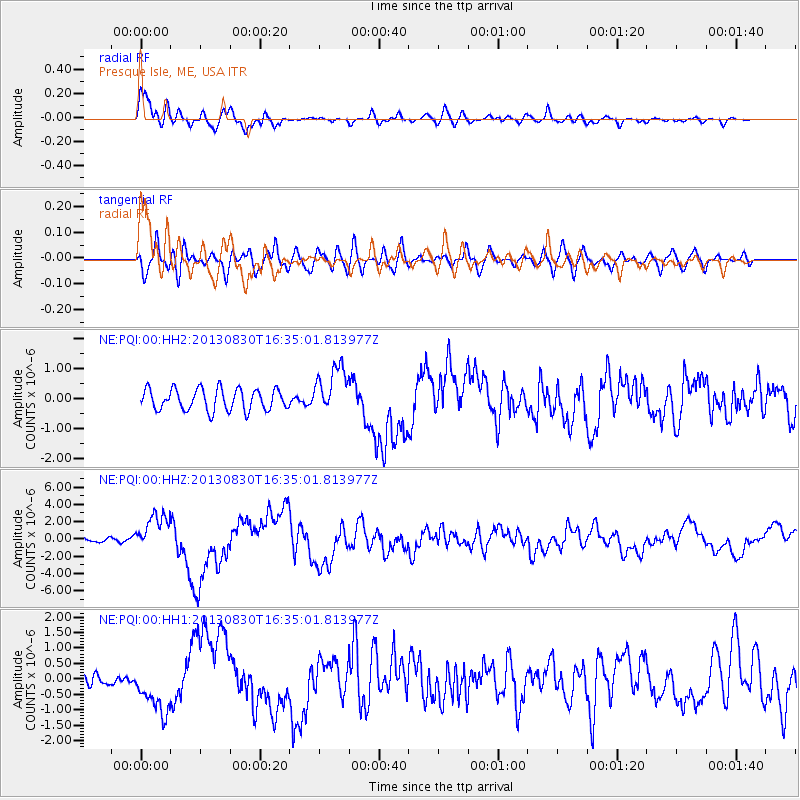
Earthquake location: Andreanof Islands, Aleutian Is.
Earthquake latitude/longitude: 51.5/-175.2
Earthquake time(UTC): 2013/08/30 (242) 16:25:02 GMT
Earthquake Depth: 29 km
Earthquake Magnitude: 7.0 MWW, 6.5 ML, 6.8 MI, 6.9 MWC, 6.9 MWB, 7.0 MWW, 7.0 MI, 7.0 MWC
Earthquake Catalog/Contributor: NEIC PDE/NEIC COMCAT
Network: NE New England Seismic Network
Station: PQI Presque Isle, ME, USA
Lat/Lon: 46.67 N/68.02 W
Elevation: 162 m
Distance: 64.0 deg
Az: 47.064 deg
Baz: 318.393 deg
Ray Param: 0.05919219
Estimated Moho Depth: 11.0 km
Estimated Crust Vp/Vs: 1.74
Assumed Crust Vp: 6.419 km/s
Estimated Crust Vs: 3.689 km/s
Estimated Crust Poisson's Ratio: 0.25
Radial Match: 88.39035 %
Radial Bump: 400
Transverse Match: 56.70723 %
Transverse Bump: 400
SOD ConfigId: 626651
Insert Time: 2014-04-18 05:08:16.507 +0000
GWidth: 2.5
Max Bumps: 400
Tol: 0.001

Signal To Noise

ChannelStoNSTALTA
NE:PQI:00:HHZ:20130830T16:35:01.813977Z3.02154832.1869064E-67.2377014E-7
NE:PQI:00:HH1:20130830T16:35:01.813977Z2.57830457.855108E-73.0466177E-7
NE:PQI:00:HH2:20130830T16:35:01.813977Z2.2173637.901554E-73.5634912E-7
Arrivals
Ps1.3 SECOND
PpPs4.5 SECOND
PsPs/PpSs5.8 SECOND