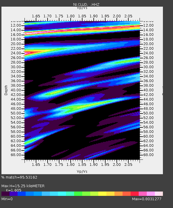
CLUD Cludinico - Earthquake Result Viewer

Earthquake location: Andreanof Islands, Aleutian Is.
Earthquake latitude/longitude: 51.5/-175.2
Earthquake time(UTC): 2013/08/30 (242) 16:25:02 GMT
Earthquake Depth: 29 km
Earthquake Magnitude: 7.0 MWW, 6.5 ML, 6.8 MI, 6.9 MWC, 6.9 MWB, 7.0 MWW, 7.0 MI, 7.0 MWC
Earthquake Catalog/Contributor: NEIC PDE/NEIC COMCAT
Network: NI North-East Italy Broadband Network
Station: CLUD Cludinico
Lat/Lon: 46.46 N/12.88 E
Elevation: 635 m
Distance: 82.1 deg
Az: 354.349 deg
Baz: 5.104 deg
Ray Param: 0.04706056
Estimated Moho Depth: 15.25 km
Estimated Crust Vp/Vs: 1.61
Assumed Crust Vp: 6.35 km/s
Estimated Crust Vs: 3.956 km/s
Estimated Crust Poisson's Ratio: 0.18
Radial Match: 95.53162 %
Radial Bump: 400
Transverse Match: 82.44387 %
Transverse Bump: 400
SOD ConfigId: 626651
Insert Time: 2014-04-18 05:08:40.928 +0000
GWidth: 2.5
Max Bumps: 400
Tol: 0.001

Signal To Noise

ChannelStoNSTALTA
NI:CLUD: :HHZ:20130830T16:36:48.977979Z40.803991.8040912E-64.4213596E-8
NI:CLUD: :HHN:20130830T16:36:48.977979Z9.904665.528793E-75.582012E-8
NI:CLUD: :HHE:20130830T16:36:48.977979Z1.13304363.7874152E-83.3426915E-8
Arrivals
Ps1.5 SECOND
PpPs6.1 SECOND
PsPs/PpSs7.6 SECOND