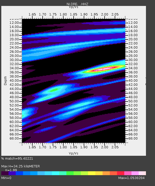
DRE Drenchia - Earthquake Result Viewer

Earthquake location: Andreanof Islands, Aleutian Is.
Earthquake latitude/longitude: 51.5/-175.2
Earthquake time(UTC): 2013/08/30 (242) 16:25:02 GMT
Earthquake Depth: 29 km
Earthquake Magnitude: 7.0 MWW, 6.5 ML, 6.8 MI, 6.9 MWC, 6.9 MWB, 7.0 MWW, 7.0 MI, 7.0 MWC
Earthquake Catalog/Contributor: NEIC PDE/NEIC COMCAT
Network: NI North-East Italy Broadband Network
Station: DRE Drenchia
Lat/Lon: 46.17 N/13.65 E
Elevation: 810 m
Distance: 82.4 deg
Az: 353.791 deg
Baz: 5.579 deg
Ray Param: 0.046899073
Estimated Moho Depth: 34.25 km
Estimated Crust Vp/Vs: 1.99
Assumed Crust Vp: 6.35 km/s
Estimated Crust Vs: 3.191 km/s
Estimated Crust Poisson's Ratio: 0.33
Radial Match: 95.40221 %
Radial Bump: 339
Transverse Match: 70.5734 %
Transverse Bump: 400
SOD ConfigId: 626651
Insert Time: 2014-04-18 05:08:43.213 +0000
GWidth: 2.5
Max Bumps: 400
Tol: 0.001

Signal To Noise

ChannelStoNSTALTA
NI:DRE: :HHZ:20130830T16:36:50.19801Z20.996331.3329623E-66.348549E-8
NI:DRE: :HHN:20130830T16:36:50.19801Z11.0281854.6683337E-74.2330935E-8
NI:DRE: :HHE:20130830T16:36:50.19801Z2.24199277.326943E-83.2680497E-8
Arrivals
Ps5.5 SECOND
PpPs16 SECOND
PsPs/PpSs21 SECOND