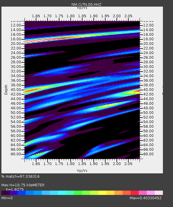
CLTN Cedars of Lebanon,TN - Earthquake Result Viewer

Earthquake location: Andreanof Islands, Aleutian Is.
Earthquake latitude/longitude: 51.5/-175.2
Earthquake time(UTC): 2013/08/30 (242) 16:25:02 GMT
Earthquake Depth: 29 km
Earthquake Magnitude: 7.0 MWW, 6.5 ML, 6.8 MI, 6.9 MWC, 6.9 MWB, 7.0 MWW, 7.0 MI, 7.0 MWC
Earthquake Catalog/Contributor: NEIC PDE/NEIC COMCAT
Network: NM Cooperative New Madrid Seismic Network
Station: CLTN Cedars of Lebanon,TN
Lat/Lon: 36.09 N/86.33 W
Elevation: 208 m
Distance: 62.1 deg
Az: 66.38 deg
Baz: 315.048 deg
Ray Param: 0.060397126
Estimated Moho Depth: 18.75 km
Estimated Crust Vp/Vs: 1.63
Assumed Crust Vp: 6.444 km/s
Estimated Crust Vs: 3.959 km/s
Estimated Crust Poisson's Ratio: 0.20
Radial Match: 97.036316 %
Radial Bump: 205
Transverse Match: 89.614555 %
Transverse Bump: 400
SOD ConfigId: 626651
Insert Time: 2014-04-18 05:08:57.599 +0000
GWidth: 2.5
Max Bumps: 400
Tol: 0.001

Signal To Noise

ChannelStoNSTALTA
NM:CLTN:00:HHZ:20130830T16:34:49.584973Z19.774642.004554E-61.0136994E-7
NM:CLTN:00:HHN:20130830T16:34:49.584973Z7.26641757.1941014E-79.900479E-8
NM:CLTN:00:HHE:20130830T16:34:49.584973Z7.66947756.745835E-78.7956906E-8
Arrivals
Ps1.9 SECOND
PpPs7.3 SECOND
PsPs/PpSs9.2 SECOND