UTMT Martin, TN - Earthquake Result Viewer
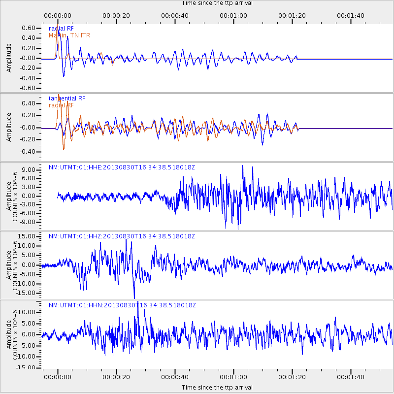
Earthquake location: Andreanof Islands, Aleutian Is.
Earthquake latitude/longitude: 51.5/-175.2
Earthquake time(UTC): 2013/08/30 (242) 16:25:02 GMT
Earthquake Depth: 29 km
Earthquake Magnitude: 7.0 MWW, 6.5 ML, 6.8 MI, 6.9 MWC, 6.9 MWB, 7.0 MWW, 7.0 MI, 7.0 MWC
Earthquake Catalog/Contributor: NEIC PDE/NEIC COMCAT
Network: NM Cooperative New Madrid Seismic Network
Station: UTMT Martin, TN
Lat/Lon: 36.35 N/88.86 W
Elevation: 110 m
Distance: 60.5 deg
Az: 67.811 deg
Baz: 314.246 deg
Ray Param: 0.061462868
Estimated Moho Depth: 10.0 km
Estimated Crust Vp/Vs: 1.65
Assumed Crust Vp: 6.444 km/s
Estimated Crust Vs: 3.911 km/s
Estimated Crust Poisson's Ratio: 0.21
Radial Match: 82.58111 %
Radial Bump: 400
Transverse Match: 79.98624 %
Transverse Bump: 400
SOD ConfigId: 626651
Insert Time: 2014-04-18 05:09:35.481 +0000
GWidth: 2.5
Max Bumps: 400
Tol: 0.001

Signal To Noise

ChannelStoNSTALTA
NM:UTMT:01:HHZ:20130830T16:34:38.518018Z3.45091561.8523621E-65.367741E-7
NM:UTMT:01:HHN:20130830T16:34:38.518018Z2.05067941.3596878E-66.630426E-7
NM:UTMT:01:HHE:20130830T16:34:38.518018Z1.46892231.0541471E-67.1763304E-7
Arrivals
Ps1.1 SECOND
PpPs3.9 SECOND
PsPs/PpSs5.0 SECOND