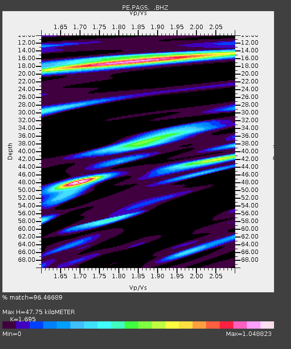
PAGS PA Geological Survey - Earthquake Result Viewer
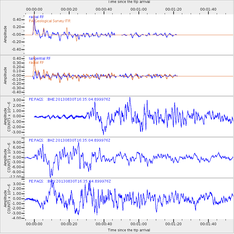
Earthquake location: Andreanof Islands, Aleutian Is.
Earthquake latitude/longitude: 51.5/-175.2
Earthquake time(UTC): 2013/08/30 (242) 16:25:02 GMT
Earthquake Depth: 29 km
Earthquake Magnitude: 7.0 MWW, 6.5 ML, 6.8 MI, 6.9 MWC, 6.9 MWB, 7.0 MWW, 7.0 MI, 7.0 MWC
Earthquake Catalog/Contributor: NEIC PDE/NEIC COMCAT
Network: PE Penn State Network
Station: PAGS PA Geological Survey
Lat/Lon: 40.23 N/76.72 W
Elevation: 120 m
Distance: 64.4 deg
Az: 57.079 deg
Baz: 316.782 deg
Ray Param: 0.05888599
Estimated Moho Depth: 47.75 km
Estimated Crust Vp/Vs: 1.70
Assumed Crust Vp: 6.121 km/s
Estimated Crust Vs: 3.611 km/s
Estimated Crust Poisson's Ratio: 0.23
Radial Match: 96.46689 %
Radial Bump: 400
Transverse Match: 80.55389 %
Transverse Bump: 400
SOD ConfigId: 626651
Insert Time: 2014-04-18 05:11:01.817 +0000
GWidth: 2.5
Max Bumps: 400
Tol: 0.001

Signal To Noise

ChannelStoNSTALTA
PE:PAGS: :BHZ:20130830T16:35:04.899976Z18.2028482.937152E-61.6135671E-7
PE:PAGS: :BHN:20130830T16:35:04.899976Z6.1068468.388839E-71.3736778E-7
PE:PAGS: :BHE:20130830T16:35:04.899976Z6.16477879.233507E-71.497784E-7
Arrivals
Ps5.6 SECOND
PpPs20 SECOND
PsPs/PpSs26 SECOND