You are here: Home > Network List > ZJ12 - Transantarctic Mountains Northern Network Stations List
> Station MICH Tinker Glacier, Antarctica > Earthquake Result Viewer
MICH Tinker Glacier, Antarctica - Earthquake Result Viewer
| Earthquake location: |
Fiji Islands Region |
| Earthquake latitude/longitude: |
-15.2/173.1 |
| Earthquake time(UTC): |
2014/11/13 (317) 10:24:18 GMT |
| Earthquake Depth: |
10 km |
| Earthquake Magnitude: |
5.7 MB |
| Earthquake Catalog/Contributor: |
NEIC PDE/NEIC COMCAT |
|
| Network: |
ZJ Transantarctic Mountains Northern Network |
| Station: |
MICH Tinker Glacier, Antarctica |
| Lat/Lon: |
73.82 S/164.10 E |
| Elevation: |
817 m |
|
| Distance: |
58.9 deg |
| Az: |
182.922 deg |
| Baz: |
10.11 deg |
| Ray Param: |
0.06256644 |
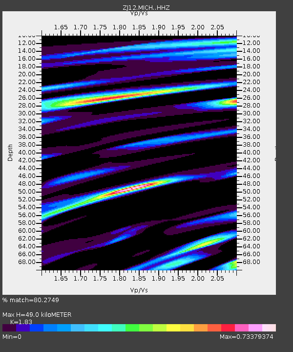
| Estimated Moho Depth: |
49.0 km |
| Estimated Crust Vp/Vs: |
1.83 |
| Assumed Crust Vp: |
6.245 km/s |
| Estimated Crust Vs: |
3.412 km/s |
| Estimated Crust Poisson's Ratio: |
0.29 |
|
| Radial Match: |
80.2749 % |
| Radial Bump: |
400 |
| Transverse Match: |
68.60523 % |
| Transverse Bump: |
400 |
| SOD ConfigId: |
3390531 |
| Insert Time: |
2019-04-14 23:28:23.365 +0000 |
| GWidth: |
2.5 |
| Max Bumps: |
400 |
| Tol: |
0.001 |
|

Signal To Noise
| Channel | StoN | STA | LTA |
| ZJ:MICH: :HHZ:20141113T10:33:45.359004Z | 7.7161474 | 7.998663E-7 | 1.0366135E-7 |
| ZJ:MICH: :HHN:20141113T10:33:45.359004Z | 9.11182 | 3.0383384E-7 | 3.334502E-8 |
| ZJ:MICH: :HHE:20141113T10:33:45.359004Z | 1.0608014 | 1.14325985E-7 | 1.07773225E-7 |
| Arrivals |
| Ps | 6.8 SECOND |
| PpPs | 21 SECOND |
| PsPs/PpSs | 28 SECOND |


