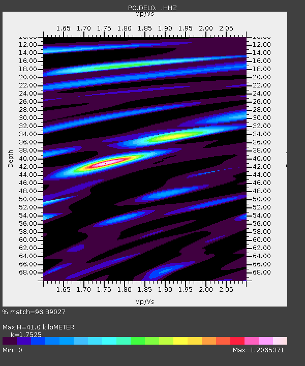
DELO DELORO MINE, ON - Earthquake Result Viewer

Earthquake location: Andreanof Islands, Aleutian Is.
Earthquake latitude/longitude: 51.5/-175.2
Earthquake time(UTC): 2013/08/30 (242) 16:25:02 GMT
Earthquake Depth: 29 km
Earthquake Magnitude: 7.0 MWW, 6.5 ML, 6.8 MI, 6.9 MWC, 6.9 MWB, 7.0 MWW, 7.0 MI, 7.0 MWC
Earthquake Catalog/Contributor: NEIC PDE/NEIC COMCAT
Network: PO Portable Observatories for Lithospheric Analysis and Research Investigating Seis
Station: DELO DELORO MINE, ON
Lat/Lon: 44.52 N/77.62 W
Elevation: 213 m
Distance: 60.9 deg
Az: 54.253 deg
Baz: 314.881 deg
Ray Param: 0.061188415
Estimated Moho Depth: 41.0 km
Estimated Crust Vp/Vs: 1.75
Assumed Crust Vp: 6.577 km/s
Estimated Crust Vs: 3.753 km/s
Estimated Crust Poisson's Ratio: 0.26
Radial Match: 96.89027 %
Radial Bump: 295
Transverse Match: 86.89659 %
Transverse Bump: 400
SOD ConfigId: 626651
Insert Time: 2014-04-18 05:11:54.398 +0000
GWidth: 2.5
Max Bumps: 400
Tol: 0.001

Signal To Noise

ChannelStoNSTALTA
PO:DELO: :HHZ:20130830T16:34:41.349988Z18.3329181.2119464E-66.610766E-8
PO:DELO: :HHN:20130830T16:34:41.349988Z7.1265124.2935682E-76.024782E-8
PO:DELO: :HHE:20130830T16:34:41.349988Z7.5405244.0639728E-75.38951E-8
Arrivals
Ps4.9 SECOND
PpPs16 SECOND
PsPs/PpSs21 SECOND