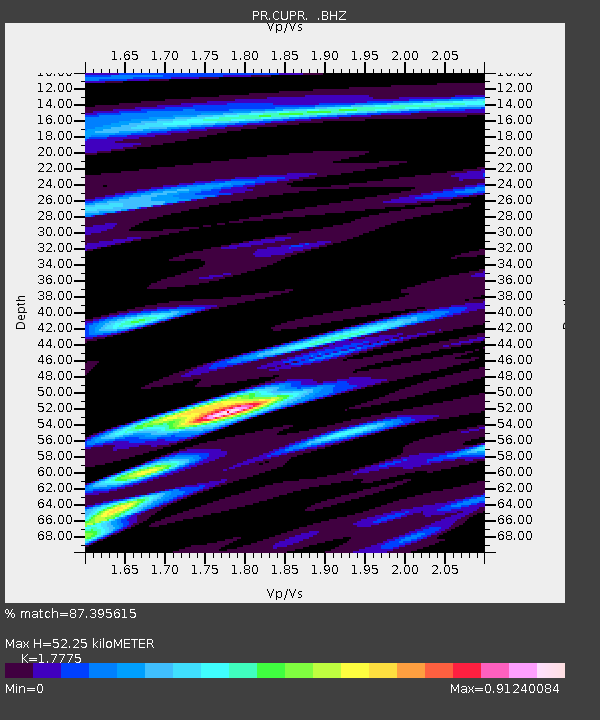
CUPR Culebra - Earthquake Result Viewer

Earthquake location: Andreanof Islands, Aleutian Is.
Earthquake latitude/longitude: 51.5/-175.2
Earthquake time(UTC): 2013/08/30 (242) 16:25:02 GMT
Earthquake Depth: 29 km
Earthquake Magnitude: 7.0 MWW, 6.5 ML, 6.8 MI, 6.9 MWC, 6.9 MWB, 7.0 MWW, 7.0 MI, 7.0 MWC
Earthquake Catalog/Contributor: NEIC PDE/NEIC COMCAT
Network: PR Puerto Rico Seismic Network (PRSN) & Puerto Rico Strong Motion Program (PRSMP)
Station: CUPR Culebra
Lat/Lon: 18.31 N/65.28 W
Elevation: 7.0 m
Distance: 87.6 deg
Az: 63.353 deg
Baz: 324.013 deg
Ray Param: 0.043154642
Estimated Moho Depth: 52.25 km
Estimated Crust Vp/Vs: 1.78
Assumed Crust Vp: 5.14 km/s
Estimated Crust Vs: 2.892 km/s
Estimated Crust Poisson's Ratio: 0.27
Radial Match: 87.395615 %
Radial Bump: 400
Transverse Match: 86.26589 %
Transverse Bump: 400
SOD ConfigId: 626651
Insert Time: 2014-04-18 05:13:14.288 +0000
GWidth: 2.5
Max Bumps: 400
Tol: 0.001

Signal To Noise

ChannelStoNSTALTA
PR:CUPR: :BHZ:20130830T16:37:16.474988Z6.801229.687647E-71.4243983E-7
PR:CUPR: :BHN:20130830T16:37:16.474988Z2.10182572.6100912E-71.241821E-7
PR:CUPR: :BHE:20130830T16:37:16.474988Z1.34791364.006902E-72.9726698E-7
Arrivals
Ps8.0 SECOND
PpPs28 SECOND
PsPs/PpSs36 SECOND