121A Cookes Peak, Deming, NM, USA - Earthquake Result Viewer
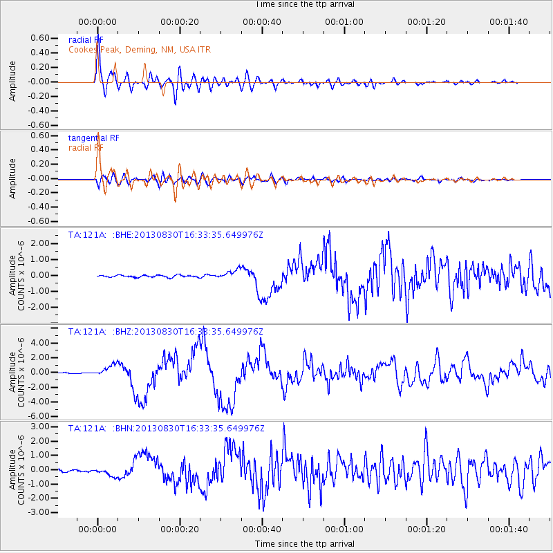
Earthquake location: Andreanof Islands, Aleutian Is.
Earthquake latitude/longitude: 51.5/-175.2
Earthquake time(UTC): 2013/08/30 (242) 16:25:02 GMT
Earthquake Depth: 29 km
Earthquake Magnitude: 7.0 MWW, 6.5 ML, 6.8 MI, 6.9 MWC, 6.9 MWB, 7.0 MWW, 7.0 MI, 7.0 MWC
Earthquake Catalog/Contributor: NEIC PDE/NEIC COMCAT
Network: TA USArray Transportable Network (new EarthScope stations)
Station: 121A Cookes Peak, Deming, NM, USA
Lat/Lon: 32.53 N/107.79 W
Elevation: 1652 m
Distance: 51.7 deg
Az: 84.055 deg
Baz: 312.659 deg
Ray Param: 0.0672184
Estimated Moho Depth: 37.75 km
Estimated Crust Vp/Vs: 1.70
Assumed Crust Vp: 6.502 km/s
Estimated Crust Vs: 3.83 km/s
Estimated Crust Poisson's Ratio: 0.23
Radial Match: 89.46956 %
Radial Bump: 400
Transverse Match: 65.02317 %
Transverse Bump: 400
SOD ConfigId: 626651
Insert Time: 2014-04-18 05:15:15.780 +0000
GWidth: 2.5
Max Bumps: 400
Tol: 0.001

Signal To Noise

ChannelStoNSTALTA
TA:121A: :BHZ:20130830T16:33:35.649976Z9.3418888.304204E-78.8892136E-8
TA:121A: :BHN:20130830T16:33:35.649976Z4.308362.937798E-76.818831E-8
TA:121A: :BHE:20130830T16:33:35.649976Z4.6266182.991073E-76.4649235E-8
Arrivals
Ps4.3 SECOND
PpPs15 SECOND
PsPs/PpSs19 SECOND