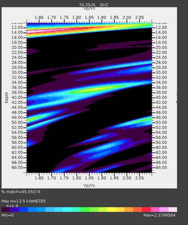
252A Lumpkin, GA, USA - Earthquake Result Viewer

Earthquake location: Andreanof Islands, Aleutian Is.
Earthquake latitude/longitude: 51.5/-175.2
Earthquake time(UTC): 2013/08/30 (242) 16:25:02 GMT
Earthquake Depth: 29 km
Earthquake Magnitude: 7.0 MWW, 6.5 ML, 6.8 MI, 6.9 MWC, 6.9 MWB, 7.0 MWW, 7.0 MI, 7.0 MWC
Earthquake Catalog/Contributor: NEIC PDE/NEIC COMCAT
Network: TA USArray Transportable Network (new EarthScope stations)
Station: 252A Lumpkin, GA, USA
Lat/Lon: 32.00 N/84.74 W
Elevation: 142 m
Distance: 66.0 deg
Az: 68.478 deg
Baz: 316.857 deg
Ray Param: 0.05788055
Estimated Moho Depth: 13.5 km
Estimated Crust Vp/Vs: 1.60
Assumed Crust Vp: 6.347 km/s
Estimated Crust Vs: 3.967 km/s
Estimated Crust Poisson's Ratio: 0.18
Radial Match: 85.05374 %
Radial Bump: 400
Transverse Match: 71.068436 %
Transverse Bump: 400
SOD ConfigId: 626651
Insert Time: 2014-04-18 05:15:40.039 +0000
GWidth: 2.5
Max Bumps: 400
Tol: 0.001

Signal To Noise

ChannelStoNSTALTA
TA:252A: :BHZ:20130830T16:35:14.875012Z11.1554771.8661843E-61.6728863E-7
TA:252A: :BHN:20130830T16:35:14.875012Z1.73299666.343841E-73.6606193E-7
TA:252A: :BHE:20130830T16:35:14.875012Z1.62858061.016649E-66.242547E-7
Arrivals
Ps1.3 SECOND
PpPs5.3 SECOND
PsPs/PpSs6.6 SECOND