You are here: Home > Network List > TA - USArray Transportable Network (new EarthScope stations) Stations List
> Station 353A Camilla, GA, USA > Earthquake Result Viewer
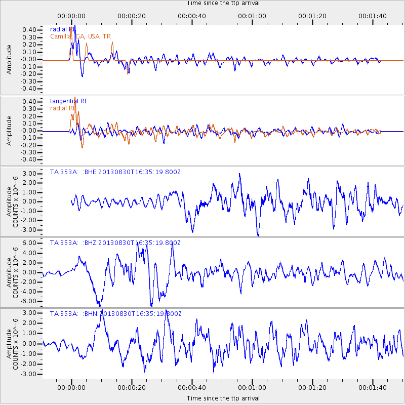
353A Camilla, GA, USA - Earthquake Result Viewer
*The percent match for this event was below the threshold and hence no stack was calculated.
| Earthquake location: |
Andreanof Islands, Aleutian Is. |
| Earthquake latitude/longitude: |
51.5/-175.2 |
| Earthquake time(UTC): |
2013/08/30 (242) 16:25:02 GMT |
| Earthquake Depth: |
29 km |
| Earthquake Magnitude: |
7.0 MWW, 6.5 ML, 6.8 MI, 6.9 MWC, 6.9 MWB, 7.0 MWW, 7.0 MI, 7.0 MWC |
| Earthquake Catalog/Contributor: |
NEIC PDE/NEIC COMCAT |
|
| Network: |
TA USArray Transportable Network (new EarthScope stations) |
| Station: |
353A Camilla, GA, USA |
| Lat/Lon: |
31.35 N/84.22 W |
| Elevation: |
54 m |
|
| Distance: |
66.7 deg |
| Az: |
68.606 deg |
| Baz: |
317.18 deg |
| Ray Param: |
$rayparam |
*The percent match for this event was below the threshold and hence was not used in the summary stack. |
|
| Radial Match: |
92.21213 % |
| Radial Bump: |
400 |
| Transverse Match: |
82.66688 % |
| Transverse Bump: |
400 |
| SOD ConfigId: |
626651 |
| Insert Time: |
2014-04-18 05:15:54.533 +0000 |
| GWidth: |
2.5 |
| Max Bumps: |
400 |
| Tol: |
0.001 |
|
Signal To Noise
| Channel | StoN | STA | LTA |
| TA:353A: :BHZ:20130830T16:35:19.800Z | 7.3356543 | 1.8630451E-6 | 2.5397122E-7 |
| TA:353A: :BHN:20130830T16:35:19.800Z | 3.8086135 | 8.307141E-7 | 2.1811456E-7 |
| TA:353A: :BHE:20130830T16:35:19.800Z | 2.2846463 | 7.610809E-7 | 3.3312853E-7 |
| Arrivals |
| Ps | |
| PpPs | |
| PsPs/PpSs | |


