833A Chaparral WMA, Artesia Wells, TX, USA - Earthquake Result Viewer
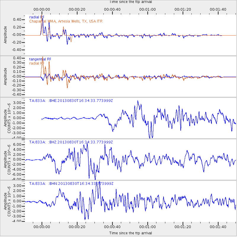
Earthquake location: Andreanof Islands, Aleutian Is.
Earthquake latitude/longitude: 51.5/-175.2
Earthquake time(UTC): 2013/08/30 (242) 16:25:02 GMT
Earthquake Depth: 29 km
Earthquake Magnitude: 7.0 MWW, 6.5 ML, 6.8 MI, 6.9 MWC, 6.9 MWB, 7.0 MWW, 7.0 MI, 7.0 MWC
Earthquake Catalog/Contributor: NEIC PDE/NEIC COMCAT
Network: TA USArray Transportable Network (new EarthScope stations)
Station: 833A Chaparral WMA, Artesia Wells, TX, USA
Lat/Lon: 28.32 N/99.39 W
Elevation: 171 m
Distance: 59.8 deg
Az: 81.595 deg
Baz: 315.506 deg
Ray Param: 0.061918546
Estimated Moho Depth: 27.25 km
Estimated Crust Vp/Vs: 1.89
Assumed Crust Vp: 6.347 km/s
Estimated Crust Vs: 3.363 km/s
Estimated Crust Poisson's Ratio: 0.30
Radial Match: 97.355484 %
Radial Bump: 383
Transverse Match: 86.597855 %
Transverse Bump: 400
SOD ConfigId: 626651
Insert Time: 2014-04-18 05:16:28.002 +0000
GWidth: 2.5
Max Bumps: 400
Tol: 0.001

Signal To Noise

ChannelStoNSTALTA
TA:833A: :BHZ:20130830T16:34:33.773999Z12.2976461.3058765E-61.0618915E-7
TA:833A: :BHN:20130830T16:34:33.773999Z5.81102664.6745834E-78.044333E-8
TA:833A: :BHE:20130830T16:34:33.773999Z4.63754134.822136E-71.0398044E-7
Arrivals
Ps4.0 SECOND
PpPs12 SECOND
PsPs/PpSs16 SECOND