C06D Leavenworth, WQ, USA - Earthquake Result Viewer
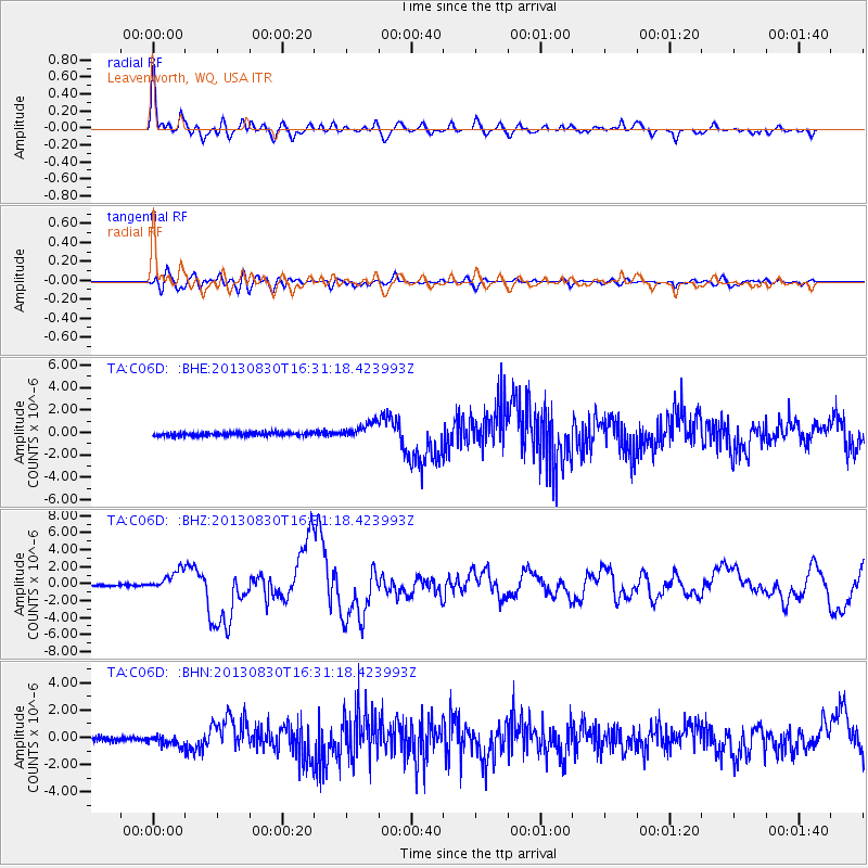
Earthquake location: Andreanof Islands, Aleutian Is.
Earthquake latitude/longitude: 51.5/-175.2
Earthquake time(UTC): 2013/08/30 (242) 16:25:02 GMT
Earthquake Depth: 29 km
Earthquake Magnitude: 7.0 MWW, 6.5 ML, 6.8 MI, 6.9 MWC, 6.9 MWB, 7.0 MWW, 7.0 MI, 7.0 MWC
Earthquake Catalog/Contributor: NEIC PDE/NEIC COMCAT
Network: TA USArray Transportable Network (new EarthScope stations)
Station: C06D Leavenworth, WQ, USA
Lat/Lon: 47.92 N/120.89 W
Elevation: 544 m
Distance: 34.6 deg
Az: 74.075 deg
Baz: 296.755 deg
Ray Param: 0.077594556
Estimated Moho Depth: 36.75 km
Estimated Crust Vp/Vs: 1.75
Assumed Crust Vp: 6.597 km/s
Estimated Crust Vs: 3.759 km/s
Estimated Crust Poisson's Ratio: 0.26
Radial Match: 89.425 %
Radial Bump: 400
Transverse Match: 72.803955 %
Transverse Bump: 400
SOD ConfigId: 626651
Insert Time: 2014-04-18 05:16:47.573 +0000
GWidth: 2.5
Max Bumps: 400
Tol: 0.001

Signal To Noise

ChannelStoNSTALTA
TA:C06D: :BHZ:20130830T16:31:18.423993Z11.6477921.1860942E-61.01829954E-7
TA:C06D: :BHN:20130830T16:31:18.423993Z2.08022623.5635256E-71.713047E-7
TA:C06D: :BHE:20130830T16:31:18.423993Z4.286697.225505E-71.6855674E-7
Arrivals
Ps4.6 SECOND
PpPs14 SECOND
PsPs/PpSs19 SECOND