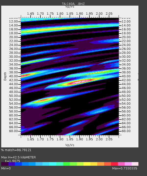
C40A Isle Royale National Park, MI, USA - Earthquake Result Viewer

Earthquake location: Andreanof Islands, Aleutian Is.
Earthquake latitude/longitude: 51.5/-175.2
Earthquake time(UTC): 2013/08/30 (242) 16:25:02 GMT
Earthquake Depth: 29 km
Earthquake Magnitude: 7.0 MWW, 6.5 ML, 6.8 MI, 6.9 MWC, 6.9 MWB, 7.0 MWW, 7.0 MI, 7.0 MWC
Earthquake Catalog/Contributor: NEIC PDE/NEIC COMCAT
Network: TA USArray Transportable Network (new EarthScope stations)
Station: C40A Isle Royale National Park, MI, USA
Lat/Lon: 47.92 N/89.15 W
Elevation: 216 m
Distance: 52.7 deg
Az: 57.583 deg
Baz: 308.394 deg
Ray Param: 0.06657002
Estimated Moho Depth: 42.5 km
Estimated Crust Vp/Vs: 1.91
Assumed Crust Vp: 6.467 km/s
Estimated Crust Vs: 3.39 km/s
Estimated Crust Poisson's Ratio: 0.31
Radial Match: 96.79121 %
Radial Bump: 400
Transverse Match: 84.09633 %
Transverse Bump: 400
SOD ConfigId: 626651
Insert Time: 2014-04-18 05:16:47.879 +0000
GWidth: 2.5
Max Bumps: 400
Tol: 0.001

Signal To Noise

ChannelStoNSTALTA
TA:C40A: :BHZ:20130830T16:33:43.050Z11.0040082.6373443E-62.3967127E-7
TA:C40A: :BHN:20130830T16:33:43.050Z3.70324187.4478584E-72.0111726E-7
TA:C40A: :BHE:20130830T16:33:43.050Z4.9119951.1651186E-62.3719868E-7
Arrivals
Ps6.3 SECOND
PpPs18 SECOND
PsPs/PpSs24 SECOND