D50A G1974 Best Township, ON, CAN - Earthquake Result Viewer
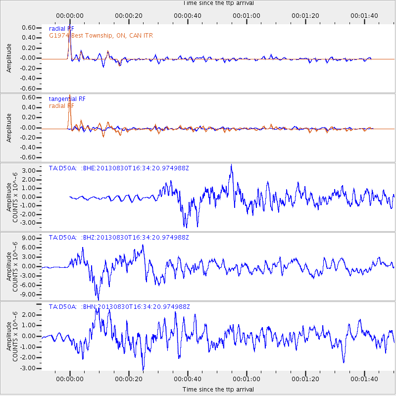
Earthquake location: Andreanof Islands, Aleutian Is.
Earthquake latitude/longitude: 51.5/-175.2
Earthquake time(UTC): 2013/08/30 (242) 16:25:02 GMT
Earthquake Depth: 29 km
Earthquake Magnitude: 7.0 MWW, 6.5 ML, 6.8 MI, 6.9 MWC, 6.9 MWB, 7.0 MWW, 7.0 MI, 7.0 MWC
Earthquake Catalog/Contributor: NEIC PDE/NEIC COMCAT
Network: TA USArray Transportable Network (new EarthScope stations)
Station: D50A G1974 Best Township, ON, CAN
Lat/Lon: 47.17 N/79.84 W
Elevation: 331 m
Distance: 57.9 deg
Az: 53.284 deg
Baz: 312.797 deg
Ray Param: 0.06312658
Estimated Moho Depth: 33.5 km
Estimated Crust Vp/Vs: 1.75
Assumed Crust Vp: 6.622 km/s
Estimated Crust Vs: 3.795 km/s
Estimated Crust Poisson's Ratio: 0.26
Radial Match: 95.83657 %
Radial Bump: 352
Transverse Match: 70.37814 %
Transverse Bump: 400
SOD ConfigId: 626651
Insert Time: 2014-04-18 05:17:05.944 +0000
GWidth: 2.5
Max Bumps: 400
Tol: 0.001

Signal To Noise

ChannelStoNSTALTA
TA:D50A: :BHZ:20130830T16:34:20.974988Z16.5589452.6701443E-61.6125088E-7
TA:D50A: :BHN:20130830T16:34:20.974988Z6.2982449.3214794E-71.4800125E-7
TA:D50A: :BHE:20130830T16:34:20.974988Z5.4794949.865229E-71.8003905E-7
Arrivals
Ps4.0 SECOND
PpPs13 SECOND
PsPs/PpSs17 SECOND