D51A Lot 18 Range III Mazenod Township, QC, CAN - Earthquake Result Viewer
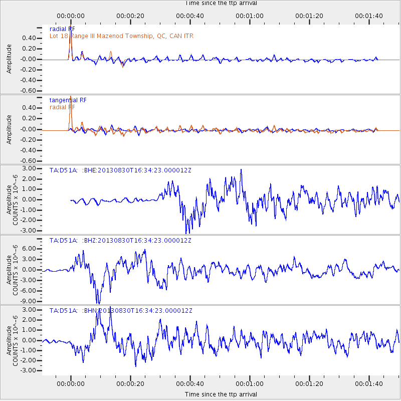
Earthquake location: Andreanof Islands, Aleutian Is.
Earthquake latitude/longitude: 51.5/-175.2
Earthquake time(UTC): 2013/08/30 (242) 16:25:02 GMT
Earthquake Depth: 29 km
Earthquake Magnitude: 7.0 MWW, 6.5 ML, 6.8 MI, 6.9 MWC, 6.9 MWB, 7.0 MWW, 7.0 MI, 7.0 MWC
Earthquake Catalog/Contributor: NEIC PDE/NEIC COMCAT
Network: TA USArray Transportable Network (new EarthScope stations)
Station: D51A Lot 18 Range III Mazenod Township, QC, CAN
Lat/Lon: 47.09 N/79.37 W
Elevation: 282 m
Distance: 58.2 deg
Az: 53.093 deg
Baz: 313.039 deg
Ray Param: 0.062940285
Estimated Moho Depth: 35.0 km
Estimated Crust Vp/Vs: 1.68
Assumed Crust Vp: 6.622 km/s
Estimated Crust Vs: 3.942 km/s
Estimated Crust Poisson's Ratio: 0.23
Radial Match: 96.52004 %
Radial Bump: 370
Transverse Match: 74.11064 %
Transverse Bump: 400
SOD ConfigId: 626651
Insert Time: 2014-04-18 05:17:09.344 +0000
GWidth: 2.5
Max Bumps: 400
Tol: 0.001

Signal To Noise

ChannelStoNSTALTA
TA:D51A: :BHZ:20130830T16:34:23.000012Z13.8052782.6091336E-61.8899537E-7
TA:D51A: :BHN:20130830T16:34:23.000012Z4.0586319.359278E-72.3060184E-7
TA:D51A: :BHE:20130830T16:34:23.000012Z6.37011539.974812E-71.5658762E-7
Arrivals
Ps3.8 SECOND
PpPs13 SECOND
PsPs/PpSs17 SECOND