D58A Chemin du LacGrosbois, Trois-Rives, QC, CAN - Earthquake Result Viewer
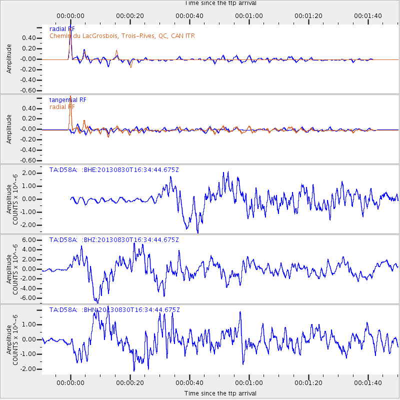
Earthquake location: Andreanof Islands, Aleutian Is.
Earthquake latitude/longitude: 51.5/-175.2
Earthquake time(UTC): 2013/08/30 (242) 16:25:02 GMT
Earthquake Depth: 29 km
Earthquake Magnitude: 7.0 MWW, 6.5 ML, 6.8 MI, 6.9 MWC, 6.9 MWB, 7.0 MWW, 7.0 MI, 7.0 MWC
Earthquake Catalog/Contributor: NEIC PDE/NEIC COMCAT
Network: TA USArray Transportable Network (new EarthScope stations)
Station: D58A Chemin du LacGrosbois, Trois-Rives, QC, CAN
Lat/Lon: 47.10 N/72.88 W
Elevation: 398 m
Distance: 61.4 deg
Az: 49.494 deg
Baz: 315.968 deg
Ray Param: 0.06086679
Estimated Moho Depth: 38.75 km
Estimated Crust Vp/Vs: 1.75
Assumed Crust Vp: 6.61 km/s
Estimated Crust Vs: 3.783 km/s
Estimated Crust Poisson's Ratio: 0.26
Radial Match: 95.29793 %
Radial Bump: 400
Transverse Match: 70.032875 %
Transverse Bump: 400
SOD ConfigId: 626651
Insert Time: 2014-04-18 05:17:24.574 +0000
GWidth: 2.5
Max Bumps: 400
Tol: 0.001

Signal To Noise

ChannelStoNSTALTA
TA:D58A: :BHZ:20130830T16:34:44.675Z8.3133942.2678043E-62.7278926E-7
TA:D58A: :BHN:20130830T16:34:44.675Z5.9812418.1245855E-71.3583444E-7
TA:D58A: :BHE:20130830T16:34:44.675Z6.28334768.6651266E-71.3790621E-7
Arrivals
Ps4.6 SECOND
PpPs15 SECOND
PsPs/PpSs20 SECOND