F52A Sundridge, ON, CAN - Earthquake Result Viewer
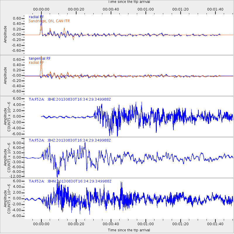
Earthquake location: Andreanof Islands, Aleutian Is.
Earthquake latitude/longitude: 51.5/-175.2
Earthquake time(UTC): 2013/08/30 (242) 16:25:02 GMT
Earthquake Depth: 29 km
Earthquake Magnitude: 7.0 MWW, 6.5 ML, 6.8 MI, 6.9 MWC, 6.9 MWB, 7.0 MWW, 7.0 MI, 7.0 MWC
Earthquake Catalog/Contributor: NEIC PDE/NEIC COMCAT
Network: TA USArray Transportable Network (new EarthScope stations)
Station: F52A Sundridge, ON, CAN
Lat/Lon: 45.80 N/79.32 W
Elevation: 351 m
Distance: 59.1 deg
Az: 54.169 deg
Baz: 313.634 deg
Ray Param: 0.062342696
Estimated Moho Depth: 41.25 km
Estimated Crust Vp/Vs: 1.81
Assumed Crust Vp: 6.577 km/s
Estimated Crust Vs: 3.644 km/s
Estimated Crust Poisson's Ratio: 0.28
Radial Match: 96.87645 %
Radial Bump: 400
Transverse Match: 82.90055 %
Transverse Bump: 400
SOD ConfigId: 626651
Insert Time: 2014-04-18 05:18:30.406 +0000
GWidth: 2.5
Max Bumps: 400
Tol: 0.001

Signal To Noise

ChannelStoNSTALTA
TA:F52A: :BHZ:20130830T16:34:29.349988Z16.6205443.398859E-62.0449745E-7
TA:F52A: :BHN:20130830T16:34:29.349988Z7.69038531.3804151E-61.7949884E-7
TA:F52A: :BHE:20130830T16:34:29.349988Z9.9078951.700486E-61.7162941E-7
Arrivals
Ps5.3 SECOND
PpPs17 SECOND
PsPs/PpSs22 SECOND