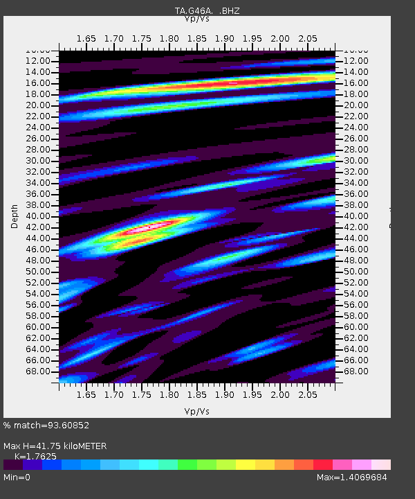
G46A Petoskey, MI, USA - Earthquake Result Viewer

Earthquake location: Andreanof Islands, Aleutian Is.
Earthquake latitude/longitude: 51.5/-175.2
Earthquake time(UTC): 2013/08/30 (242) 16:25:02 GMT
Earthquake Depth: 29 km
Earthquake Magnitude: 7.0 MWW, 6.5 ML, 6.8 MI, 6.9 MWC, 6.9 MWB, 7.0 MWW, 7.0 MI, 7.0 MWC
Earthquake Catalog/Contributor: NEIC PDE/NEIC COMCAT
Network: TA USArray Transportable Network (new EarthScope stations)
Station: G46A Petoskey, MI, USA
Lat/Lon: 45.32 N/84.86 W
Elevation: 239 m
Distance: 56.6 deg
Az: 57.694 deg
Baz: 311.567 deg
Ray Param: 0.06399368
Estimated Moho Depth: 41.75 km
Estimated Crust Vp/Vs: 1.76
Assumed Crust Vp: 6.483 km/s
Estimated Crust Vs: 3.678 km/s
Estimated Crust Poisson's Ratio: 0.26
Radial Match: 93.60852 %
Radial Bump: 400
Transverse Match: 75.71175 %
Transverse Bump: 400
SOD ConfigId: 626651
Insert Time: 2014-04-18 05:18:59.543 +0000
GWidth: 2.5
Max Bumps: 400
Tol: 0.001

Signal To Noise

ChannelStoNSTALTA
TA:G46A: :BHZ:20130830T16:34:11.550Z12.4522994.355152E-63.4974687E-7
TA:G46A: :BHN:20130830T16:34:11.550Z4.90527962.8562022E-65.82271E-7
TA:G46A: :BHE:20130830T16:34:11.550Z3.60733581.8910068E-65.242115E-7
Arrivals
Ps5.2 SECOND
PpPs17 SECOND
PsPs/PpSs22 SECOND