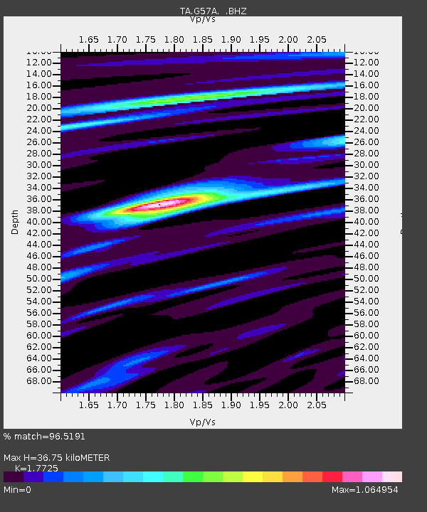
G57A Newington, ON, CAN - Earthquake Result Viewer
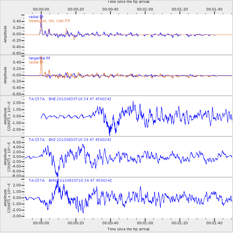
Earthquake location: Andreanof Islands, Aleutian Is.
Earthquake latitude/longitude: 51.5/-175.2
Earthquake time(UTC): 2013/08/30 (242) 16:25:02 GMT
Earthquake Depth: 29 km
Earthquake Magnitude: 7.0 MWW, 6.5 ML, 6.8 MI, 6.9 MWC, 6.9 MWB, 7.0 MWW, 7.0 MI, 7.0 MWC
Earthquake Catalog/Contributor: NEIC PDE/NEIC COMCAT
Network: TA USArray Transportable Network (new EarthScope stations)
Station: G57A Newington, ON, CAN
Lat/Lon: 45.10 N/74.99 W
Elevation: 96 m
Distance: 61.8 deg
Az: 52.265 deg
Baz: 315.777 deg
Ray Param: 0.060606554
Estimated Moho Depth: 36.75 km
Estimated Crust Vp/Vs: 1.77
Assumed Crust Vp: 6.419 km/s
Estimated Crust Vs: 3.622 km/s
Estimated Crust Poisson's Ratio: 0.27
Radial Match: 96.5191 %
Radial Bump: 364
Transverse Match: 77.95492 %
Transverse Bump: 400
SOD ConfigId: 626651
Insert Time: 2014-04-18 05:19:10.483 +0000
GWidth: 2.5
Max Bumps: 400
Tol: 0.001

Signal To Noise

ChannelStoNSTALTA
TA:G57A: :BHZ:20130830T16:34:47.450024Z8.5482972.268638E-62.6539064E-7
TA:G57A: :BHN:20130830T16:34:47.450024Z7.5368099.095627E-71.2068274E-7
TA:G57A: :BHE:20130830T16:34:47.450024Z4.71801427.8517076E-71.6641975E-7
Arrivals
Ps4.6 SECOND
PpPs15 SECOND
PsPs/PpSs20 SECOND