You are here: Home > Network List > TA - USArray Transportable Network (new EarthScope stations) Stations List
> Station H17A Grant Village (NPS), Yellowstone Nt. Park, WY, USA > Earthquake Result Viewer
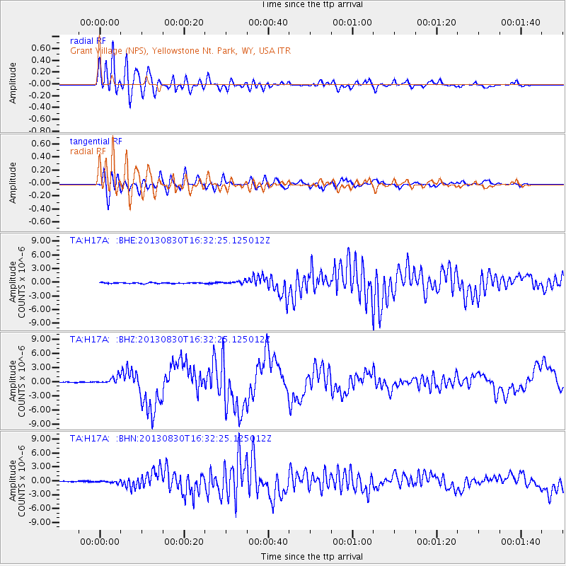
H17A Grant Village (NPS), Yellowstone Nt. Park, WY, USA - Earthquake Result Viewer
*The percent match for this event was below the threshold and hence no stack was calculated.
| Earthquake location: |
Andreanof Islands, Aleutian Is. |
| Earthquake latitude/longitude: |
51.5/-175.2 |
| Earthquake time(UTC): |
2013/08/30 (242) 16:25:02 GMT |
| Earthquake Depth: |
29 km |
| Earthquake Magnitude: |
7.0 MWW, 6.5 ML, 6.8 MI, 6.9 MWC, 6.9 MWB, 7.0 MWW, 7.0 MI, 7.0 MWC |
| Earthquake Catalog/Contributor: |
NEIC PDE/NEIC COMCAT |
|
| Network: |
TA USArray Transportable Network (new EarthScope stations) |
| Station: |
H17A Grant Village (NPS), Yellowstone Nt. Park, WY, USA |
| Lat/Lon: |
44.40 N/110.58 W |
| Elevation: |
2400 m |
|
| Distance: |
42.6 deg |
| Az: |
73.186 deg |
| Baz: |
303.489 deg |
| Ray Param: |
$rayparam |
*The percent match for this event was below the threshold and hence was not used in the summary stack. |
|
| Radial Match: |
92.87938 % |
| Radial Bump: |
400 |
| Transverse Match: |
78.181244 % |
| Transverse Bump: |
400 |
| SOD ConfigId: |
626651 |
| Insert Time: |
2014-04-18 05:19:19.927 +0000 |
| GWidth: |
2.5 |
| Max Bumps: |
400 |
| Tol: |
0.001 |
|
Signal To Noise
| Channel | StoN | STA | LTA |
| TA:H17A: :BHZ:20130830T16:32:25.125012Z | 11.544008 | 7.9665426E-7 | 6.90102E-8 |
| TA:H17A: :BHN:20130830T16:32:25.125012Z | 3.1747682 | 2.3573004E-7 | 7.4251105E-8 |
| TA:H17A: :BHE:20130830T16:32:25.125012Z | 3.5238576 | 3.2671608E-7 | 9.271546E-8 |
| Arrivals |
| Ps | |
| PpPs | |
| PsPs/PpSs | |


