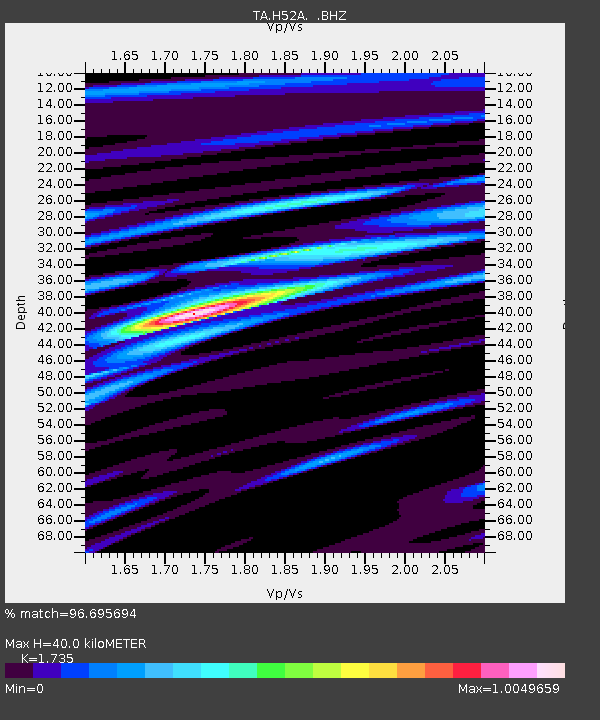
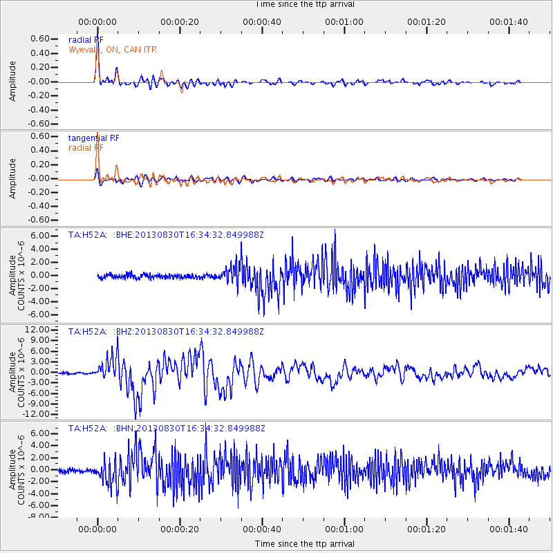
H52A Wyevale, ON, CAN - Earthquake Result Viewer

Earthquake location: Andreanof Islands, Aleutian Is.
Earthquake latitude/longitude: 51.5/-175.2
Earthquake time(UTC): 2013/08/30 (242) 16:25:02 GMT
Earthquake Depth: 29 km
Earthquake Magnitude: 7.0 MWW, 6.5 ML, 6.8 MI, 6.9 MWC, 6.9 MWB, 7.0 MWW, 7.0 MI, 7.0 MWC
Earthquake Catalog/Contributor: NEIC PDE/NEIC COMCAT
Network: TA USArray Transportable Network (new EarthScope stations)
Station: H52A Wyevale, ON, CAN
Lat/Lon: 44.64 N/79.89 W
Elevation: 209 m
Distance: 59.6 deg
Az: 55.458 deg
Baz: 313.89 deg
Ray Param: 0.062007442
Estimated Moho Depth: 40.0 km
Estimated Crust Vp/Vs: 1.74
Assumed Crust Vp: 6.577 km/s
Estimated Crust Vs: 3.791 km/s
Estimated Crust Poisson's Ratio: 0.25
Radial Match: 96.695694 %
Radial Bump: 400
Transverse Match: 83.47601 %
Transverse Bump: 400
SOD ConfigId: 626651
Insert Time: 2014-04-18 05:19:33.844 +0000
GWidth: 2.5
Max Bumps: 400
Tol: 0.001

Signal To Noise

ChannelStoNSTALTA
TA:H52A: :BHZ:20130830T16:34:32.849988Z19.863883.4223497E-61.722901E-7
TA:H52A: :BHN:20130830T16:34:32.849988Z8.1497932.0103098E-62.4667006E-7
TA:H52A: :BHE:20130830T16:34:32.849988Z4.72190241.2938073E-62.7400128E-7
Arrivals
Ps4.7 SECOND
PpPs16 SECOND
PsPs/PpSs21 SECOND