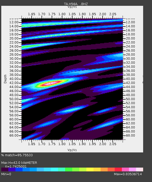
H56A Elgin, ON, CAN - Earthquake Result Viewer

Earthquake location: Andreanof Islands, Aleutian Is.
Earthquake latitude/longitude: 51.5/-175.2
Earthquake time(UTC): 2013/08/30 (242) 16:25:02 GMT
Earthquake Depth: 29 km
Earthquake Magnitude: 7.0 MWW, 6.5 ML, 6.8 MI, 6.9 MWC, 6.9 MWB, 7.0 MWW, 7.0 MI, 7.0 MWC
Earthquake Catalog/Contributor: NEIC PDE/NEIC COMCAT
Network: TA USArray Transportable Network (new EarthScope stations)
Station: H56A Elgin, ON, CAN
Lat/Lon: 44.59 N/76.26 W
Elevation: 137 m
Distance: 61.5 deg
Az: 53.407 deg
Baz: 315.423 deg
Ray Param: 0.060776997
Estimated Moho Depth: 42.0 km
Estimated Crust Vp/Vs: 1.74
Assumed Crust Vp: 6.577 km/s
Estimated Crust Vs: 3.774 km/s
Estimated Crust Poisson's Ratio: 0.25
Radial Match: 95.75533 %
Radial Bump: 400
Transverse Match: 78.25961 %
Transverse Bump: 400
SOD ConfigId: 626651
Insert Time: 2014-04-18 05:19:42.530 +0000
GWidth: 2.5
Max Bumps: 400
Tol: 0.001

Signal To Noise

ChannelStoNSTALTA
TA:H56A: :BHZ:20130830T16:34:45.625012Z15.9422512.86198E-61.795217E-7
TA:H56A: :BHN:20130830T16:34:45.625012Z5.17642451.2650297E-62.443829E-7
TA:H56A: :BHE:20130830T16:34:45.625012Z8.6223741.0431739E-61.2098454E-7
Arrivals
Ps5.0 SECOND
PpPs17 SECOND
PsPs/PpSs22 SECOND