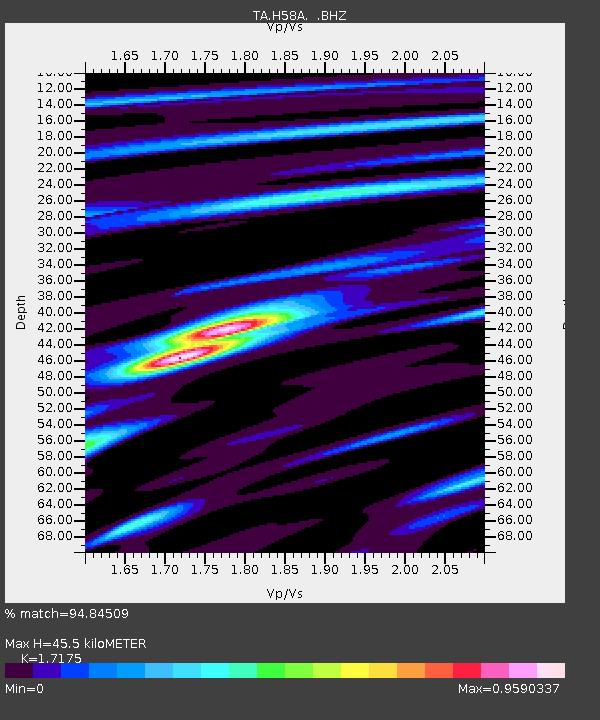
H58A Gabriels, NY, USA - Earthquake Result Viewer

Earthquake location: Andreanof Islands, Aleutian Is.
Earthquake latitude/longitude: 51.5/-175.2
Earthquake time(UTC): 2013/08/30 (242) 16:25:02 GMT
Earthquake Depth: 29 km
Earthquake Magnitude: 7.0 MWW, 6.5 ML, 6.8 MI, 6.9 MWC, 6.9 MWB, 7.0 MWW, 7.0 MI, 7.0 MWC
Earthquake Catalog/Contributor: NEIC PDE/NEIC COMCAT
Network: TA USArray Transportable Network (new EarthScope stations)
Station: H58A Gabriels, NY, USA
Lat/Lon: 44.42 N/74.18 W
Elevation: 537 m
Distance: 62.7 deg
Az: 52.336 deg
Baz: 316.375 deg
Ray Param: 0.060022388
Estimated Moho Depth: 45.5 km
Estimated Crust Vp/Vs: 1.72
Assumed Crust Vp: 6.419 km/s
Estimated Crust Vs: 3.738 km/s
Estimated Crust Poisson's Ratio: 0.24
Radial Match: 94.84509 %
Radial Bump: 344
Transverse Match: 70.53732 %
Transverse Bump: 400
SOD ConfigId: 626651
Insert Time: 2014-04-18 05:19:47.128 +0000
GWidth: 2.5
Max Bumps: 400
Tol: 0.001

Signal To Noise

ChannelStoNSTALTA
TA:H58A: :BHZ:20130830T16:34:53.399976Z10.8439282.1766941E-62.007293E-7
TA:H58A: :BHN:20130830T16:34:53.399976Z3.65091478.5224707E-72.3343387E-7
TA:H58A: :BHE:20130830T16:34:53.399976Z5.29865657.303733E-71.3784123E-7
Arrivals
Ps5.3 SECOND
PpPs18 SECOND
PsPs/PpSs24 SECOND