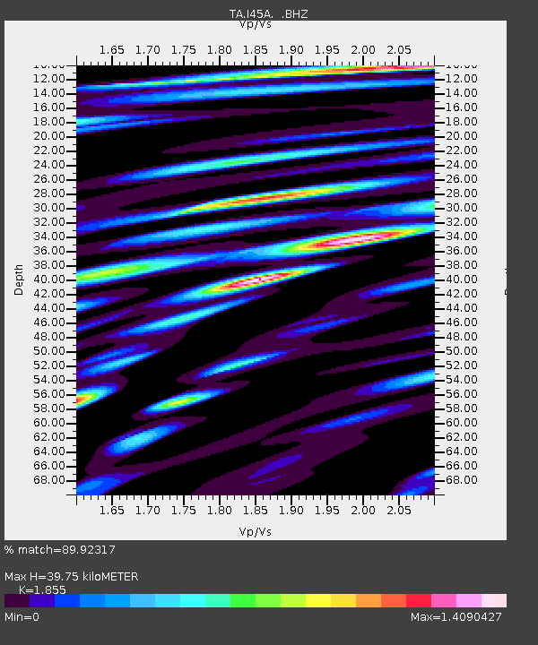
I45A Fountain, MI, USA - Earthquake Result Viewer
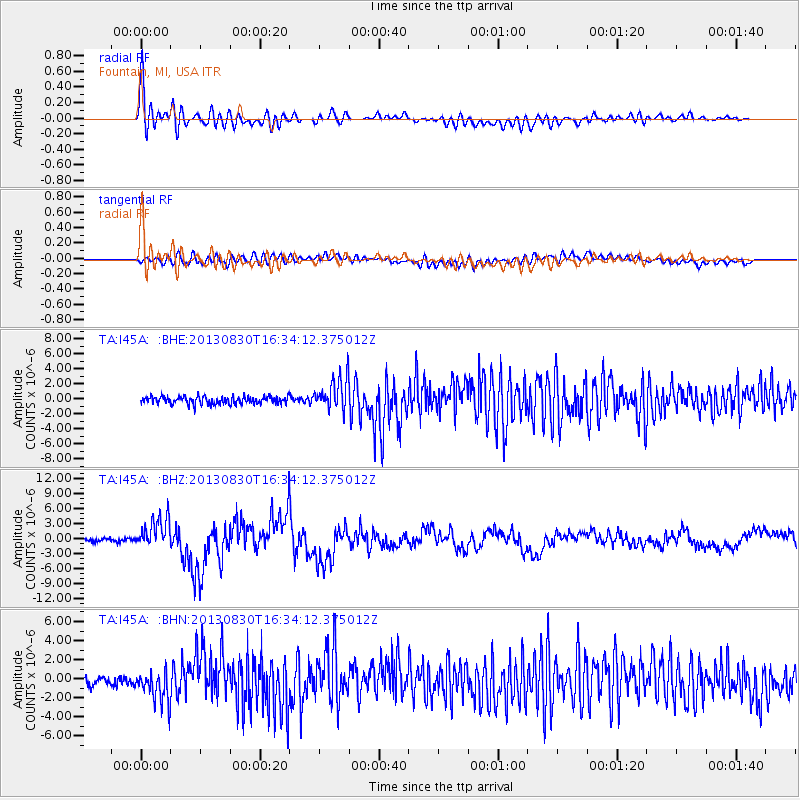
Earthquake location: Andreanof Islands, Aleutian Is.
Earthquake latitude/longitude: 51.5/-175.2
Earthquake time(UTC): 2013/08/30 (242) 16:25:02 GMT
Earthquake Depth: 29 km
Earthquake Magnitude: 7.0 MWW, 6.5 ML, 6.8 MI, 6.9 MWC, 6.9 MWB, 7.0 MWW, 7.0 MI, 7.0 MWC
Earthquake Catalog/Contributor: NEIC PDE/NEIC COMCAT
Network: TA USArray Transportable Network (new EarthScope stations)
Station: I45A Fountain, MI, USA
Lat/Lon: 44.04 N/86.23 W
Elevation: 215 m
Distance: 56.7 deg
Az: 59.619 deg
Baz: 311.663 deg
Ray Param: 0.06391569
Estimated Moho Depth: 39.75 km
Estimated Crust Vp/Vs: 1.86
Assumed Crust Vp: 6.53 km/s
Estimated Crust Vs: 3.52 km/s
Estimated Crust Poisson's Ratio: 0.30
Radial Match: 89.92317 %
Radial Bump: 400
Transverse Match: 76.507 %
Transverse Bump: 400
SOD ConfigId: 626651
Insert Time: 2014-04-18 05:20:02.867 +0000
GWidth: 2.5
Max Bumps: 400
Tol: 0.001

Signal To Noise

ChannelStoNSTALTA
TA:I45A: :BHZ:20130830T16:34:12.375012Z8.8540363.0688966E-63.4660988E-7
TA:I45A: :BHN:20130830T16:34:12.375012Z3.41806481.6793975E-64.913299E-7
TA:I45A: :BHE:20130830T16:34:12.375012Z4.32177732.1417745E-64.9557724E-7
Arrivals
Ps5.5 SECOND
PpPs17 SECOND
PsPs/PpSs22 SECOND