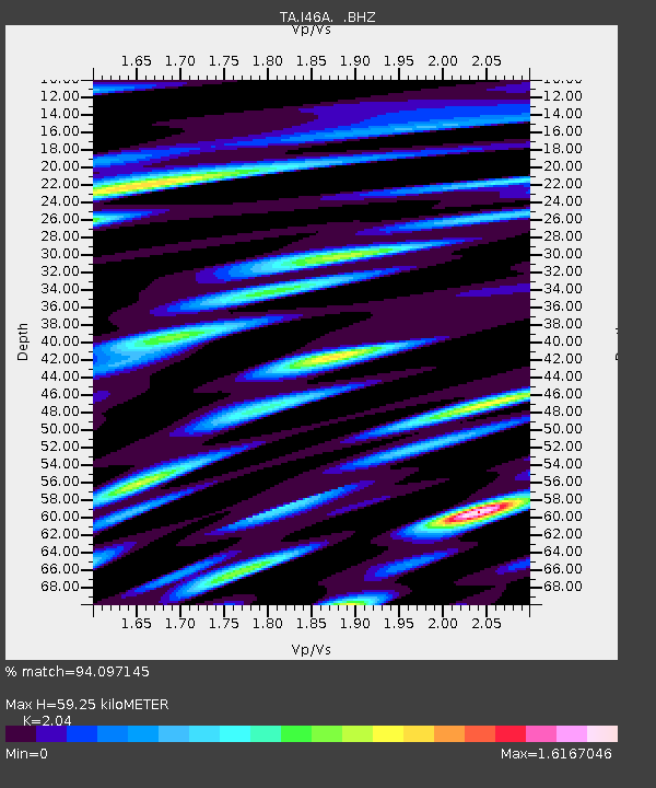
I46A Reed City, MI, USA - Earthquake Result Viewer

Earthquake location: Andreanof Islands, Aleutian Is.
Earthquake latitude/longitude: 51.5/-175.2
Earthquake time(UTC): 2013/08/30 (242) 16:25:02 GMT
Earthquake Depth: 29 km
Earthquake Magnitude: 7.0 MWW, 6.5 ML, 6.8 MI, 6.9 MWC, 6.9 MWB, 7.0 MWW, 7.0 MI, 7.0 MWC
Earthquake Catalog/Contributor: NEIC PDE/NEIC COMCAT
Network: TA USArray Transportable Network (new EarthScope stations)
Station: I46A Reed City, MI, USA
Lat/Lon: 43.94 N/85.45 W
Elevation: 359 m
Distance: 57.2 deg
Az: 59.251 deg
Baz: 312.008 deg
Ray Param: 0.063597746
Estimated Moho Depth: 59.25 km
Estimated Crust Vp/Vs: 2.04
Assumed Crust Vp: 6.483 km/s
Estimated Crust Vs: 3.178 km/s
Estimated Crust Poisson's Ratio: 0.34
Radial Match: 94.097145 %
Radial Bump: 400
Transverse Match: 88.219376 %
Transverse Bump: 400
SOD ConfigId: 626651
Insert Time: 2014-04-18 05:20:06.294 +0000
GWidth: 2.5
Max Bumps: 400
Tol: 0.001

Signal To Noise

ChannelStoNSTALTA
TA:I46A: :BHZ:20130830T16:34:15.823987Z18.1277484.020853E-62.2180653E-7
TA:I46A: :BHN:20130830T16:34:15.823987Z2.331189.2843356E-73.9826762E-7
TA:I46A: :BHE:20130830T16:34:15.823987Z3.46646121.3650032E-63.9377426E-7
Arrivals
Ps9.9 SECOND
PpPs27 SECOND
PsPs/PpSs37 SECOND