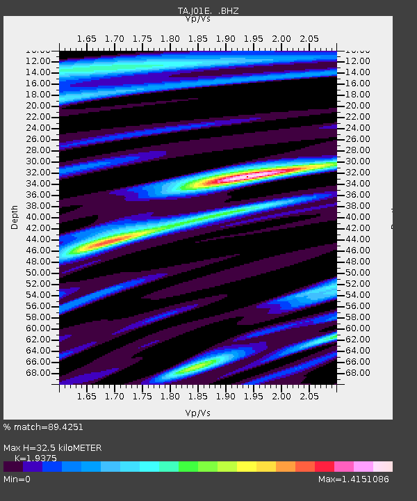
J01E Myrtle Point, OR, USA - Earthquake Result Viewer
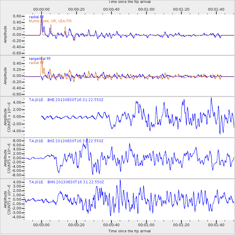
Earthquake location: Andreanof Islands, Aleutian Is.
Earthquake latitude/longitude: 51.5/-175.2
Earthquake time(UTC): 2013/08/30 (242) 16:25:02 GMT
Earthquake Depth: 29 km
Earthquake Magnitude: 7.0 MWW, 6.5 ML, 6.8 MI, 6.9 MWC, 6.9 MWB, 7.0 MWW, 7.0 MI, 7.0 MWC
Earthquake Catalog/Contributor: NEIC PDE/NEIC COMCAT
Network: TA USArray Transportable Network (new EarthScope stations)
Station: J01E Myrtle Point, OR, USA
Lat/Lon: 43.16 N/123.93 W
Elevation: 128 m
Distance: 35.1 deg
Az: 83.169 deg
Baz: 302.058 deg
Ray Param: 0.07734712
Estimated Moho Depth: 32.5 km
Estimated Crust Vp/Vs: 1.94
Assumed Crust Vp: 6.522 km/s
Estimated Crust Vs: 3.366 km/s
Estimated Crust Poisson's Ratio: 0.32
Radial Match: 89.4251 %
Radial Bump: 400
Transverse Match: 74.81951 %
Transverse Bump: 400
SOD ConfigId: 626651
Insert Time: 2014-04-18 05:20:29.727 +0000
GWidth: 2.5
Max Bumps: 400
Tol: 0.001

Signal To Noise

ChannelStoNSTALTA
TA:J01E: :BHZ:20130830T16:31:22.550Z2.7718358.378569E-73.0227514E-7
TA:J01E: :BHN:20130830T16:31:22.550Z1.36608223.315531E-72.4270363E-7
TA:J01E: :BHE:20130830T16:31:22.550Z2.46568586.1522474E-72.4951467E-7
Arrivals
Ps5.0 SECOND
PpPs14 SECOND
PsPs/PpSs19 SECOND