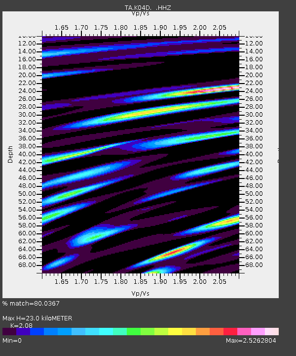
K04D Chiloquin, OR, USA - Earthquake Result Viewer
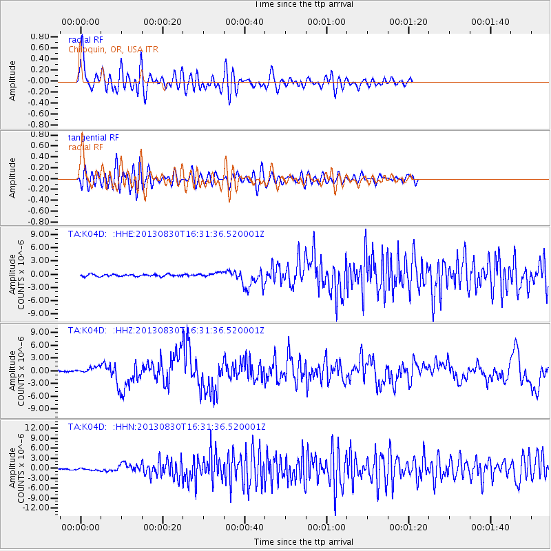
Earthquake location: Andreanof Islands, Aleutian Is.
Earthquake latitude/longitude: 51.5/-175.2
Earthquake time(UTC): 2013/08/30 (242) 16:25:02 GMT
Earthquake Depth: 29 km
Earthquake Magnitude: 7.0 MWW, 6.5 ML, 6.8 MI, 6.9 MWC, 6.9 MWB, 7.0 MWW, 7.0 MI, 7.0 MWC
Earthquake Catalog/Contributor: NEIC PDE/NEIC COMCAT
Network: TA USArray Transportable Network (new EarthScope stations)
Station: K04D Chiloquin, OR, USA
Lat/Lon: 42.62 N/121.75 W
Elevation: 1315 m
Distance: 36.7 deg
Az: 82.474 deg
Baz: 302.973 deg
Ray Param: 0.07646284
Estimated Moho Depth: 23.0 km
Estimated Crust Vp/Vs: 2.08
Assumed Crust Vp: 6.597 km/s
Estimated Crust Vs: 3.172 km/s
Estimated Crust Poisson's Ratio: 0.35
Radial Match: 80.0367 %
Radial Bump: 400
Transverse Match: 67.44989 %
Transverse Bump: 400
SOD ConfigId: 626651
Insert Time: 2014-04-18 05:21:08.295 +0000
GWidth: 2.5
Max Bumps: 400
Tol: 0.001

Signal To Noise

ChannelStoNSTALTA
TA:K04D: :HHZ:20130830T16:31:36.520001Z6.65190037.9175487E-71.1902687E-7
TA:K04D: :HHN:20130830T16:31:36.520001Z1.28610122.9811721E-72.3179918E-7
TA:K04D: :HHE:20130830T16:31:36.520001Z2.12414464.780307E-72.2504621E-7
Arrivals
Ps4.0 SECOND
PpPs10 SECOND
PsPs/PpSs14 SECOND