K43A Burlington, WI, USA - Earthquake Result Viewer
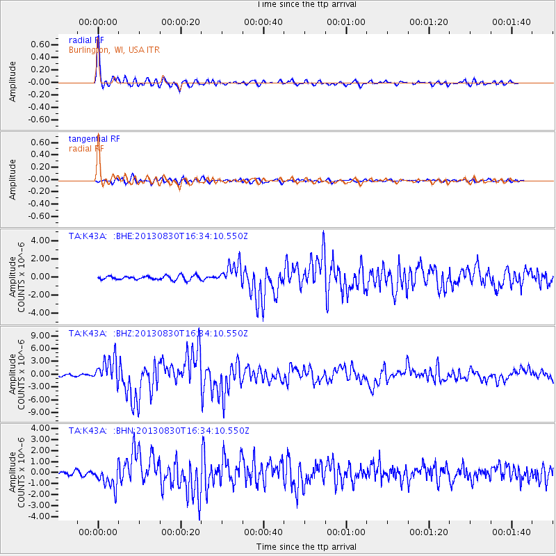
Earthquake location: Andreanof Islands, Aleutian Is.
Earthquake latitude/longitude: 51.5/-175.2
Earthquake time(UTC): 2013/08/30 (242) 16:25:02 GMT
Earthquake Depth: 29 km
Earthquake Magnitude: 7.0 MWW, 6.5 ML, 6.8 MI, 6.9 MWC, 6.9 MWB, 7.0 MWW, 7.0 MI, 7.0 MWC
Earthquake Catalog/Contributor: NEIC PDE/NEIC COMCAT
Network: TA USArray Transportable Network (new EarthScope stations)
Station: K43A Burlington, WI, USA
Lat/Lon: 42.70 N/88.33 W
Elevation: 264 m
Distance: 56.5 deg
Az: 62.028 deg
Baz: 311.555 deg
Ray Param: 0.06408595
Estimated Moho Depth: 37.25 km
Estimated Crust Vp/Vs: 1.62
Assumed Crust Vp: 6.571 km/s
Estimated Crust Vs: 4.062 km/s
Estimated Crust Poisson's Ratio: 0.19
Radial Match: 96.81538 %
Radial Bump: 400
Transverse Match: 85.0631 %
Transverse Bump: 400
SOD ConfigId: 626651
Insert Time: 2014-04-18 05:21:13.322 +0000
GWidth: 2.5
Max Bumps: 400
Tol: 0.001

Signal To Noise

ChannelStoNSTALTA
TA:K43A: :BHZ:20130830T16:34:10.550Z18.051893.0384963E-61.6832013E-7
TA:K43A: :BHN:20130830T16:34:10.550Z8.0856971.0169078E-61.2576626E-7
TA:K43A: :BHE:20130830T16:34:10.550Z5.31466961.1770438E-62.2147076E-7
Arrivals
Ps3.7 SECOND
PpPs14 SECOND
PsPs/PpSs18 SECOND