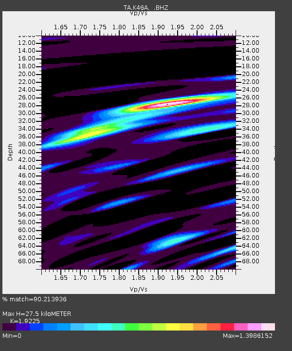
K46A Dorr, MI, USA - Earthquake Result Viewer

Earthquake location: Andreanof Islands, Aleutian Is.
Earthquake latitude/longitude: 51.5/-175.2
Earthquake time(UTC): 2013/08/30 (242) 16:25:02 GMT
Earthquake Depth: 29 km
Earthquake Magnitude: 7.0 MWW, 6.5 ML, 6.8 MI, 6.9 MWC, 6.9 MWB, 7.0 MWW, 7.0 MI, 7.0 MWC
Earthquake Catalog/Contributor: NEIC PDE/NEIC COMCAT
Network: TA USArray Transportable Network (new EarthScope stations)
Station: K46A Dorr, MI, USA
Lat/Lon: 42.69 N/85.78 W
Elevation: 213 m
Distance: 57.9 deg
Az: 60.547 deg
Baz: 312.474 deg
Ray Param: 0.06317505
Estimated Moho Depth: 27.5 km
Estimated Crust Vp/Vs: 1.92
Assumed Crust Vp: 6.483 km/s
Estimated Crust Vs: 3.372 km/s
Estimated Crust Poisson's Ratio: 0.31
Radial Match: 90.213936 %
Radial Bump: 400
Transverse Match: 78.68383 %
Transverse Bump: 400
SOD ConfigId: 626651
Insert Time: 2014-04-18 05:21:14.226 +0000
GWidth: 2.5
Max Bumps: 400
Tol: 0.001

Signal To Noise

ChannelStoNSTALTA
TA:K46A: :BHZ:20130830T16:34:20.474988Z24.5213972.7960853E-61.1402635E-7
TA:K46A: :BHN:20130830T16:34:20.474988Z3.41434981.2101657E-63.5443517E-7
TA:K46A: :BHE:20130830T16:34:20.474988Z4.9518811.3392337E-62.7044948E-7
Arrivals
Ps4.1 SECOND
PpPs12 SECOND
PsPs/PpSs16 SECOND