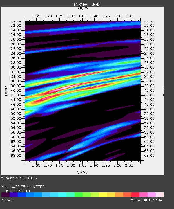
KMSC Kings Mountain, Blacksburg, SC, USA - Earthquake Result Viewer

Earthquake location: Andreanof Islands, Aleutian Is.
Earthquake latitude/longitude: 51.5/-175.2
Earthquake time(UTC): 2013/08/30 (242) 16:25:02 GMT
Earthquake Depth: 29 km
Earthquake Magnitude: 7.0 MWW, 6.5 ML, 6.8 MI, 6.9 MWC, 6.9 MWB, 7.0 MWW, 7.0 MI, 7.0 MWC
Earthquake Catalog/Contributor: NEIC PDE/NEIC COMCAT
Network: TA USArray Transportable Network (new EarthScope stations)
Station: KMSC Kings Mountain, Blacksburg, SC, USA
Lat/Lon: 35.14 N/81.33 W
Elevation: 240 m
Distance: 65.6 deg
Az: 63.854 deg
Baz: 316.834 deg
Ray Param: 0.05810683
Estimated Moho Depth: 38.25 km
Estimated Crust Vp/Vs: 1.79
Assumed Crust Vp: 6.419 km/s
Estimated Crust Vs: 3.596 km/s
Estimated Crust Poisson's Ratio: 0.27
Radial Match: 98.00152 %
Radial Bump: 289
Transverse Match: 89.02792 %
Transverse Bump: 400
SOD ConfigId: 626651
Insert Time: 2014-04-18 05:21:43.875 +0000
GWidth: 2.5
Max Bumps: 400
Tol: 0.001

Signal To Noise

ChannelStoNSTALTA
TA:KMSC: :BHZ:20130830T16:35:12.648999Z13.4642072.1351004E-61.5857603E-7
TA:KMSC: :BHN:20130830T16:35:12.648999Z7.01325138.041775E-71.1466543E-7
TA:KMSC: :BHE:20130830T16:35:12.648999Z5.00321536.7978345E-71.3586933E-7
Arrivals
Ps4.9 SECOND
PpPs16 SECOND
PsPs/PpSs21 SECOND